Make a donation
Gear up for your next adventure:
As an Amazon Associate, this site earns from qualifying purchases at no extra cost to you.
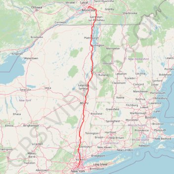
Montréal - New York
Interactive trail map
Make a donation
Gear up for your next adventure:
As an Amazon Associate, this site earns from qualifying purchases at no extra cost to you.
Trail profile
- Distance: 396.2 mi
- Elevation gain: 4,860 m
- Maximum elevation: 301 m
- Elevation loss: 4,927 m
- Minimum elevation: -2 m
Make a donation
Gear up for your next adventure:
As an Amazon Associate, this site earns from qualifying purchases at no extra cost to you.
About this trail
Name: Montréal - New York trail, distance, elevation, map, profile, GPS track
Coordinates: 40.74476 -74.00863 45.52562 -73.24881
Make a donation
Gear up for your next adventure:
As an Amazon Associate, this site earns from qualifying purchases at no extra cost to you.
Other hiking, mountain biking, running and outdoor activity trails
Click on a trail to view its statistics, map and profile.
Old Field Preserve Trails
United States > New York > Westchester County > Town of Lewisboro
Distance: 3.9 mi • Elevation gain: 134 m • Maximum elevation: 209 m
Track 124
United States > New York > Westchester County > Town of Yorktown
Description:
Distance: 4.2 mi • Elevation gain: 152 m • Maximum elevation: 210 m
Westchester RiverWalk
United States > New York > Westchester County > Village of Tarrytown
Distance: 1.5 mi • Elevation gain: 90 m • Maximum elevation: 71 m
Make a donation
Gear up for your next adventure:
As an Amazon Associate, this site earns from qualifying purchases at no extra cost to you.
Pierreville - Leclercville
Canada > Quebec > Urban agglomeration of Montreal > Montreal
#Bike #Pierreville #Leclercville #Atlantic
Distance: 75.1 mi • Elevation gain: 324 m • Maximum elevation: 36 m
Big Slide Mountain Loop
United States > New York > Essex County > Town of Keene
Lop hike from Garden Parking to Big Slide Mountain via Phelps Trail, Big Slide Trail, The Brothers Trail, Third Brother, Second Brother and First Brother in the High Peaks Wilderness. #Hiking #Loop #Mountain #Nature #Wilderness
Distance: 9.0 mi • Elevation gain: 855 m • Maximum elevation: 1,252 m
Make a donation
Gear up for your next adventure:
As an Amazon Associate, this site earns from qualifying purchases at no extra cost to you.
Mount Skylight
United States > New York > Essex County
Hike to Mount Skylight via Adirondack Loj Road, Heart Lake, Van Hoevenberg Trail, Marcy Dam, Avalanche Pass Trail, Avalanche Camp, Lake Arnold Trail, Lake Arnold, Mount Marcy Trail, Lake Tear of the Clouds, Four Corners and Skylight Trail in the High Peaks Wilderness and the Adirondack Park. #Hiking #Mountain…
Distance: 20.5 mi • Elevation gain: 1,295 m • Maximum elevation: 1,492 m
Palisades Interstate Park Loop
United States > New Jersey > Bergen County > Alpine
Loop hike along the Hudson River via Long Path, Shore Trail, Peanut Leap Cascade, Giant Stairs, Blue and white Trail, State Line Lookout and Border Monument in the Palisades Interstate Park. #Hiking #Loop #River #Nature #Forest #Park #Falls #Overlook
Distance: 4.6 mi • Elevation gain: 391 m • Maximum elevation: 164 m
Make a donation
Gear up for your next adventure:
As an Amazon Associate, this site earns from qualifying purchases at no extra cost to you.
Salaberry-de-Valleyfield - Montréal
Canada > Quebec > Beauharnois-Salaberry > Salaberry-de-Valleyfield
#Bike
Distance: 55.9 mi • Elevation gain: 363 m • Maximum elevation: 70 m
Make a donation
Gear up for your next adventure:
As an Amazon Associate, this site earns from qualifying purchases at no extra cost to you.
East Hawkesbury - Montréal
Canada > Ontario > Prescott and Russell Counties > East Hawkesbury
#Bike #EastHawkesbury #Montréal
Distance: 56.8 mi • Elevation gain: 393 m • Maximum elevation: 91 m
Montréal - Lanoraie
Canada > Quebec > Urban agglomeration of Montreal > Montreal
Saint Lawrence River. #Bike #Montréal #Lanoraie #SaintLawrence
Distance: 43.6 mi • Elevation gain: 181 m • Maximum elevation: 52 m
Make a donation
Gear up for your next adventure:
As an Amazon Associate, this site earns from qualifying purchases at no extra cost to you.
Arboretum Morgan Yellow Trail
Canada > Quebec > Urban agglomeration of Montreal > Sainte-Anne-de-Bellevue
#Hiking #Snowshoeing #Ski
Distance: 2.8 mi • Elevation gain: 33 m • Maximum elevation: 56 m
Make a donation
Gear up for your next adventure:
As an Amazon Associate, this site earns from qualifying purchases at no extra cost to you.
Cascade Mountain and Porter Mountain
United States > New York > Essex County > Town of Keene
High Peaks Wilderness. #Hiking #Snowshoeing #Mountain #Forest #Nature
Distance: 5.7 mi • Elevation gain: 671 m • Maximum elevation: 1,225 m
Make a donation
Gear up for your next adventure:
As an Amazon Associate, this site earns from qualifying purchases at no extra cost to you.
Hurricane Mountain
United States > New York > Essex County > Town of Keene > Town of Elizabethtown
Hike to the Hurricane Mountain in the Hurricane Mountain Wilderness. #Hiking #Mountain #Nature #Forest #Wilderness
Distance: 3.2 mi • Elevation gain: 588 m • Maximum elevation: 1,103 m
Mount Marcy, Table Top and Phelps Mountain
United States > New York > Essex County
Hike from Heart Lake to Mount Marcy, Table Top and Phelps Mountain via Van Hoevenberg Trail, Marcy Dam, Phelps Mountain Trail, Indian Falls and Tabletop Mountain Trail in the High Peaks Wilderness and the Adirondacks Park. #Hiking #Mountain #Nature #Forest #Lake #Falls #River #Wilderness #Park
Distance: 18.3 mi • Elevation gain: 1,679 m • Maximum elevation: 1,612 m
Mount Redfield and Cliff Mountain
United States > New York > Essex County
Hike from Heart Lake to Mount Redfield and Cliff Mountain via Van Hoevenberg Trail, Marcy Dam, Avalanche Pass Trail, Avalanche Camp, Lake Arnold Trail, Lake Arnold, Mount Marcy Trail, Mount Redfield Trail and Cliff Mountain Trail in the High Peaks Wilderness and Adirondack Park. #Hiking #Mountain #Nature…
Distance: 18.5 mi • Elevation gain: 1,399 m • Maximum elevation: 1,388 m
Make a donation
Gear up for your next adventure:
As an Amazon Associate, this site earns from qualifying purchases at no extra cost to you.
Dix Mountain Loop
United States > New York > Essex County > Town of Keene
Loop hike on the Dix Range via Boquet Forks Trail, Shoebox Falls, Lillypad Pond, Grace Peak, Grace Peak Trail, South Dix Lookout, South Dix, Dix Range Trail, Macomb Mountain, Hough Peak, Beckhorn Trail, Dix Mountain, Dix Trail and Round Pond in the High Peaks Wilderness and the Adirondack Park. #Hiking #Loop…
Distance: 16.8 mi • Elevation gain: 1,577 m • Maximum elevation: 1,456 m
Mount Marcy, Mount Skylight and Gray Peak
United States > New York > Essex County > Town of Keene
Return hike from Mount Marcy to Heart Lake via Mount Marcy Trail, Schofield Cobble, Four Corners, Skylight Trail, Lake Tear of the Clouds, Gray Peak Trail, Van Hoevenberg Trail, Indian Falls and Marcy Dam Pond in the High Peaks Wilderness and the Adirondack Park. #Hiking #Mountain #Nature #Forest #Lake #Falls…
Distance: 11.1 mi • Elevation gain: 607 m • Maximum elevation: 1,612 m
Mount Colden Loop
United States > New York > Essex County
Loop hike from Heart Lake to Mount Colden via Van Hoevenberg Trail, Marcy Dam Pond, Avalanche Pass Trail, Avalanche Pass, Avalanche Lake, Lake Colden, Mount Colden Trail, L. Morgan Porter Trail, Lake Arnold and Lake Arnold Trail in the High Peaks Wilderness and the Adirondack Park. #Hiking #Loop #Mountain…
Distance: 13.5 mi • Elevation gain: 1,000 m • Maximum elevation: 1,415 m
Make a donation
Gear up for your next adventure:
As an Amazon Associate, this site earns from qualifying purchases at no extra cost to you.
Giant Mountain and Rocky Peak Ridge
United States > New York > Essex County > Town of Keene
Hike from Chapel Pond to Giant Mountain and Rocky Peak Ridge via Ridge Trail, Ridge Lookout, Giant Washbowl, Roaring Brook Trail, East Trail and Giant East Slide Lookout in the Giant Mountain Wilderness and Adirondack Park. #Hiking #Mountain #Nature #Forest #Lake #Park #Wilderness
Distance: 8.2 mi • Elevation gain: 1,336 m • Maximum elevation: 1,387 m
Saddleback Mountain
United States > New York > Essex County > Town of Keene
Hike from Garden Parking Area to Saddleback Mountain via Phelps Trail, Orebed Brook Trail and State Range Trail in the Johns Brook Primitive Area, the High Peaks Wilderness and the Adirondack Park. #Hiking #Mountain #Nature #Forest #River #Park #Wilderness
Distance: 15.2 mi • Elevation gain: 1,085 m • Maximum elevation: 1,361 m
Allen Mountain
United States > New York > Essex County > Town of Newcomb
Hike / snowshoes from East River Parking to Allen Mountain via East River Trail, Hudson River, Lake Jimmy, Lake Sally, Allen Mountain Trail and Allen Lookout North in the High Peaks Wilderness and the Adirondack Park. #Hiking #Snowshoeing #Mountain #Nature #Forest #Lake #River #Park #Wilderness #Adirondack
Distance: 17.8 mi • Elevation gain: 1,060 m • Maximum elevation: 1,302 m
Bear Mountain Loop Trail in Mount Riga State Park
United States > Connecticut > Northwest Hills Planning Region > Salisbury
The Bear Mountain Loop Trail offers a delightful hiking experience characterized by its diverse terrain and stunning vistas. Hikers can enjoy the rugged beauty of rock scrambles leading to the summit, where the remnants of a historic stone tower provide a picturesque backdrop for breathtaking views of the…
Distance: 6.2 mi • Elevation gain: 479 m • Maximum elevation: 701 m
Make a donation
Gear up for your next adventure:
As an Amazon Associate, this site earns from qualifying purchases at no extra cost to you.
Long Path and Shore Loop in Palisades Interstate Park
United States > New Jersey > Bergen County > Alpine
This loop hike offers a captivating blend of natural beauty and rugged terrain, featuring panoramic views of the Hudson River and dramatic cliffs. Hikers can encounter diverse landscapes, including rocky descents, lush woodlands, and serene waterfronts, with spots ideal for resting and taking in the…
Distance: 6.1 mi • Elevation gain: 291 m • Maximum elevation: 169 m
State Line Lookout, White Shore, Giant Steps and Long Path Loop in Trail in Palisades Interstate Park
United States > New Jersey > Bergen County > Alpine
This loop hike offers an invigorating blend of stunning vistas and diverse terrain. Hikers can enjoy sweeping views of the Hudson River and the New York City skyline, while navigating through a variety of landscapes, including rocky outcrops and serene forest paths. Notable features along the route include the…
Distance: 4.0 mi • Elevation gain: 316 m • Maximum elevation: 166 m
Devil's Pulpit Overlook Loop via Hickey Trail, Peeskawso Peak Trail and Mohican Monument Trail in Monument Mountain Reservation
United States > Massachusetts > Berkshire County > Great Barrington
The Devil's Pulpit Overlook Loop on Monument Mountain offers a moderately challenging hike rich in both natural beauty and historical significance. Combining the Hickey Trail, Peeskawso Peak Trail, and Mohican Monument Trail, the loop winds through dense forest, revealing ancient quartzite rock formations and…
Distance: 2.5 mi • Elevation gain: 205 m • Maximum elevation: 464 m
Storm King Mountain via Butter Hill Trail, Stillman Trail and Bypass Trail in Storm King State Park
United States > New York > Orange County > Town of Cornwall > Village of Cornwall-on-Hudson
The Storm King Mountain Loop is a rewarding, moderately challenging hike that brings scenic views and diverse terrain, making it popular among both locals and visitors to New York's Hudson Valley. The trail offers impressive vistas over the Hudson River, with sweeping views of the Catskill Mountains to the…
Distance: 2.4 mi • Elevation gain: 170 m • Maximum elevation: 405 m
Make a donation
Gear up for your next adventure:
As an Amazon Associate, this site earns from qualifying purchases at no extra cost to you.
Bull Hill Loop in Hudson Highlands State Park
United States > New York > Putnam County
The Bull Hill Loop offers a scenic and varied hike, with diverse viewpoints over the Hudson River and surrounding highlands. The trail provides steady elevation that can be challenging, but hikers are rewarded with lookouts toward Storm King Mountain, the village of Cold Spring, and even the distant New York…
Distance: 5.4 mi • Elevation gain: 426 m • Maximum elevation: 421 m
Cascade Mountain Trail to Cascade Mountain and Porter Mountain in High Peaks Wilderness
United States > New York > Essex County > Town of Keene
The hike along the Cascade Mountain Trail to both Cascade and Porter Mountains offers a rewarding experience with breathtaking views of the surrounding Adirondack peaks and Lake Champlain. The well-maintained trail features a gradual ascent with rocky sections that culminate in stunning panoramic vistas from…
Distance: 6.0 mi • Elevation gain: 668 m • Maximum elevation: 1,226 m
Breakneck Ridge Loop via Breakneck Ridge Trail, Breakneck Bypass Trail and Wilkinson Trail in Hudson Highlands State Park Preserve
United States > New York > Dutchess County > Town of Fishkill > Dutchess Junction
The Breakneck Ridge Loop is a thrilling hiking adventure, characterized by its steep ascents and exhilarating rock scrambles. Along the route, hikers are treated to spectacular panoramic views of the Hudson River and surrounding mountains, particularly at the Flagpole area and other scenic points. The trail…
Distance: 3.2 mi • Elevation gain: 380 m • Maximum elevation: 364 m
Anthony's Nose in Hudson Highlands State Park
United States > New York > Putnam County > Manitou
The hike to Anthony's Nose offers an excellent balance of moderate difficulty and breathtaking views. As you ascend, the trail winds through rocky paths, with occasional steeper sections, ultimately revealing spectacular overlooks of the Hudson River, Bear Mountain Bridge, and the surrounding hills. Along…
Distance: 2.1 mi • Elevation gain: 209 m • Maximum elevation: 265 m
Make a donation
Gear up for your next adventure:
As an Amazon Associate, this site earns from qualifying purchases at no extra cost to you.
South Beacon Mountain via Casino Trail in Hudson Highlands State Park
United States > New York > Dutchess County > City of Beacon
The hike to South Beacon Mountain via the Casino Trail offers a memorable journey through scenic terrain and historic remnants. As you ascend, you’ll encounter views that stretch across the Hudson River, Hudson Highlands, and surrounding valleys, with several spots offering breathtaking panoramas. The trail…
Distance: 4.0 mi • Elevation gain: 418 m • Maximum elevation: 478 m
Mount Marcy via Van Hoevenberg Trail in High Peaks Wilderness
United States > New York > Essex County
The Van Hoevenberg Trail to Mount Marcy is one of the most popular routes to summit New York's highest peak. The route offers a mix of forested sections, notable landmarks like the Marcy Dam and Indian Falls with its scenic views of the MacIntyre Range, and a thrilling rock-scramble to the summit as the…
Distance: 15.0 mi • Elevation gain: 1,029 m • Maximum elevation: 1,612 m
Cascade Mountain Trail in High Peaks Wilderness
United States > New York > Essex County > Town of Keene
The Cascade Mountain Trail in the Adirondacks offers hikers a moderately challenging ascent through dense forests, leading to a bald summit with panoramic views of the surrounding High Peaks. Along the route, hikers can observe the diverse flora of the Adirondack Park and, upon reaching the summit, enjoy…
Distance: 4.5 mi • Elevation gain: 565 m • Maximum elevation: 1,226 m
Storm King Mountain Loop via Butter Hill Trail, Stillman Trail and Bypass Trail
United States > New York > Orange County > Town of Cornwall > Village of Cornwall-on-Hudson
The Storm King Mountain Loop offers hikers a rewarding experience with its diverse terrain and panoramic vistas. The journey begins with a steep ascent up Butter Hill, leading to expansive views of the Hudson River and the surrounding mountains. As you continue along the Stillman Trail, the path meanders…
Distance: 2.3 mi • Elevation gain: 167 m • Maximum elevation: 404 m
Make a donation
Gear up for your next adventure:
As an Amazon Associate, this site earns from qualifying purchases at no extra cost to you.
Bull Hill Short Loop via Undercliff Trail in Hudson Highlands State Park Preserve
United States > New York > Putnam County
The Bull Hill Short Loop via the Undercliff Trail in Hudson Highlands State Park Preserve offers hikers captivating vistas of the Hudson River, with clear views of Storm King Mountain and Breakneck Ridge. Along the trail, remnants of the historic Cornish Estate provide a glimpse into the area's past. The path…
Distance: 4.4 mi • Elevation gain: 374 m • Maximum elevation: 338 m
Betsy Sluder Nature Preserve Trails
United States > New York > Westchester County > Armonk
Distance: 2.7 mi • Elevation gain: 102 m • Maximum elevation: 189 m
Make a donation
Gear up for your next adventure:
As an Amazon Associate, this site earns from qualifying purchases at no extra cost to you.
Glowegee Creek Preserve Loop Trails
United States > New York > Saratoga County > Town of Galway > Parkis Mills
Distance: 3.2 mi • Elevation gain: 78 m • Maximum elevation: 232 m
Wonder Lake State Park loop hike
United States > New York > Putnam County > Kent Hills
Distance: 5.6 mi • Elevation gain: 160 m • Maximum elevation: 328 m
Three Lakes Loop (Teatown Lake, Vernay Lake and Shadow Lake) via Briarcliff-Peekskill Trail
United States > New York > Westchester County
Description:
Distance: 5.8 mi • Elevation gain: 210 m • Maximum elevation: 182 m
Saxon Woods Loop Hike
United States > New York > Westchester County > Village of Scarsdale
Distance: 3.7 mi • Elevation gain: 30 m • Maximum elevation: 64 m
Make a donation
Gear up for your next adventure:
As an Amazon Associate, this site earns from qualifying purchases at no extra cost to you.
Buxton Gorge
United States > New York > Westchester County > Town of Bedford
Distance: 2.4 mi • Elevation gain: 76 m • Maximum elevation: 134 m
Halmi Preserve and Hearst Mead Preserve trails
United States > New York > Westchester County > Town of North Salem > Grant Corner
Distance: 3.6 mi • Elevation gain: 176 m • Maximum elevation: 224 m
Estherwood Trail
United States > New York > Westchester County > Village of Dobbs Ferry
Distance: 2.6 mi • Elevation gain: 106 m • Maximum elevation: 141 m
Rockefeller State Park loop hike
United States > New York > Westchester County > Village of Sleepy Hollow
Distance: 6.8 mi • Elevation gain: 184 m • Maximum elevation: 157 m
Make a donation
Gear up for your next adventure:
As an Amazon Associate, this site earns from qualifying purchases at no extra cost to you.
Saxon Woods Park - Yellow and White trails loop
United States > New York > Westchester County > Village of Scarsdale
Distance: 3.2 mi • Elevation gain: 94 m • Maximum elevation: 64 m
Teatown Lake Reservation: Overlook Trail, Hidden Valley Loop and Phenology Trail
United States > New York > Westchester County > Town of Yorktown > Glendale
Distance: 4.3 mi • Elevation gain: 157 m • Maximum elevation: 179 m
Kitchawan Nature Preserve trails
United States > New York > Westchester County > Town of Yorktown > Kitchawan
Distance: 5.5 mi • Elevation gain: 157 m • Maximum elevation: 122 m
Peabody Preserve Outdoor Classroom trails
United States > New York > Westchester County > Village of Sleepy Hollow > Philipse Manor
Distance: 1.9 mi • Elevation gain: 40 m • Maximum elevation: 21 m
Make a donation
Gear up for your next adventure:
As an Amazon Associate, this site earns from qualifying purchases at no extra cost to you.
Saxon Woods Park
United States > New York > Westchester County > Village of Scarsdale
Distance: 3.0 mi • Elevation gain: 46 m • Maximum elevation: 65 m
From Nelsonville to the Cornish-Undercliff Junction via Nelsonvill Trail, Washburn Trail and Cornish Trail
United States > New York > Putnam County > Village of Nelsonville
Hudson Highlands State Park, Bull Hill, Nelsonville Trail, Washburn Trail, Cornish Trail, Undercliff Trail
Distance: 7.2 mi • Elevation gain: 437 m • Maximum elevation: 327 m
To the top of Manhattan
United States > New York > New York County > New York
Distance: 1.6 mi • Elevation gain: 71 m • Maximum elevation: 63 m
Cornish Trail from trailhead to Undercliff Trail Junction (upper) as well as Undercliff Trail from Cornish Trail Junction (upper) to Breakneck-view point
United States > New York > Putnam County
Hudson Highlands State Park, Cornish Trail, Undercliff Trail, Bull Hill
Distance: 6.3 mi • Elevation gain: 398 m • Maximum elevation: 338 m
Make a donation
Gear up for your next adventure:
As an Amazon Associate, this site earns from qualifying purchases at no extra cost to you.
Woodlands Legacy Field Park trails
United States > New York > Westchester County > Lake Mohegan
Distance: 5.3 mi • Elevation gain: 177 m • Maximum elevation: 174 m
Hunter Brook Preserve loop
United States > New York > Westchester County > Town of Yorktown
Distance: 2.1 mi • Elevation gain: 52 m • Maximum elevation: 94 m
Queens County Farm Museum
United States > New York > Queens County > New York
Distance: 2.4 mi • Elevation gain: 16 m • Maximum elevation: 41 m
Hudson Highlands State Park - Breakneck Ridge Trail, Undercliff Trail and Brook Trail
United States > New York > Dutchess County > City of Beacon
Description:
Distance: 2.2 mi • Elevation gain: 274 m • Maximum elevation: 270 m
Make a donation
Gear up for your next adventure:
As an Amazon Associate, this site earns from qualifying purchases at no extra cost to you.
Irvington Woods South
United States > New York > Westchester County > Village of Irvington
Distance: 3.9 mi • Elevation gain: 189 m • Maximum elevation: 135 m
Palisades Loop Hike via Shore Trail and Long Path
United States > New Jersey > Bergen County > Alpine
Distance: 5.2 mi • Elevation gain: 277 m • Maximum elevation: 139 m
Pocantico Lake County Park - White Trail and Dam
United States > New York > Westchester County > Town of Mount Pleasant
Distance: 3.5 mi • Elevation gain: 101 m • Maximum elevation: 110 m
Pinecliff Audubon Sanctuary
United States > New York > Westchester County > Chappaqua
Distance: 3.3 mi • Elevation gain: 146 m • Maximum elevation: 183 m
Make a donation
Gear up for your next adventure:
As an Amazon Associate, this site earns from qualifying purchases at no extra cost to you.
Undercliff Trail from Nelsonville to Breakneck-view point on Bull Hill
United States > New York > Putnam County > Village of Nelsonville
Distance: 4.6 mi • Elevation gain: 320 m • Maximum elevation: 325 m
Irvington Woods (West) Track
United States > New York > Westchester County > Village of Irvington
Distance: 5.2 mi • Elevation gain: 170 m • Maximum elevation: 145 m
Hutchinson River Pathway
United States > New York > Westchester County > Town/Village of Harrison
Distance: 4.6 mi • Elevation gain: 85 m • Maximum elevation: 42 m
Grossman Preserve trails
United States > New York > Westchester County > Town of Lewisboro
Distance: 1.6 mi • Elevation gain: 75 m • Maximum elevation: 147 m
Make a donation
Gear up for your next adventure:
As an Amazon Associate, this site earns from qualifying purchases at no extra cost to you.
Gedney Park Central
United States > New York > Westchester County > Millwood
Distance: 1.2 mi • Elevation gain: 26 m • Maximum elevation: 134 m
Mountain Lakes Park trails
United States > New York > Westchester County > Town of North Salem
Distance: 5.9 mi • Elevation gain: 250 m • Maximum elevation: 277 m
Hudson paddle and wheel - Hadley to Luzerne
United States > New York > Warren County > Town of Warrensburg
Distance: 15.6 mi • Elevation gain: 185 m • Maximum elevation: 207 m
Hardscrabble Wilderness Area trails
United States > New York > Westchester County > Village of Briarcliff Manor
Distance: 5.3 mi • Elevation gain: 203 m • Maximum elevation: 159 m
Make a donation
Gear up for your next adventure:
As an Amazon Associate, this site earns from qualifying purchases at no extra cost to you.
Mountain Lakes Park loop
United States > New York > Westchester County > Town of North Salem
Distance: 6.0 mi • Elevation gain: 248 m • Maximum elevation: 298 m
Old Croton Aqueduct Trail and Bronx
United States > New York > Westchester County > Village of Croton-on-Hudson
Distance: 44.0 mi • Elevation gain: 823 m • Maximum elevation: 80 m
Leatherstocking Trail
United States > New York > Westchester County > Town of Mamaroneck
Distance: 7.9 mi • Elevation gain: 123 m • Maximum elevation: 48 m
Gedney Park West
United States > New York > Westchester County > Millwood
Distance: 2.4 mi • Elevation gain: 119 m • Maximum elevation: 170 m
Make a donation
Gear up for your next adventure:
As an Amazon Associate, this site earns from qualifying purchases at no extra cost to you.
Palisades Shore Trail and Long Trail loop
United States > New Jersey > Bergen County > Fort Lee > Coytesville
Distance: 3.9 mi • Elevation gain: 209 m • Maximum elevation: 109 m
Crawford / Rye Hills parks loop
United States > New York > Westchester County > Village of Port Chester
Distance: 1.7 mi • Elevation gain: 40 m • Maximum elevation: 65 m
Edith Read Wildlife Sanctuary trails
United States > New York > Westchester County > City of Rye
Distance: 3.6 mi • Elevation gain: 27 m • Maximum elevation: 11 m
Hunt-Parker Memorial Sanctuary
United States > New York > Westchester County > Town of Bedford
Description:
Distance: 6.1 mi • Elevation gain: 269 m • Maximum elevation: 187 m
Make a donation
Gear up for your next adventure:
As an Amazon Associate, this site earns from qualifying purchases at no extra cost to you.
Tenafly Nature Center trails loop
United States > New Jersey > Bergen County > Tenafly
Distance: 3.2 mi • Elevation gain: 33 m • Maximum elevation: 137 m
Juhring Nature Preserve trails
United States > New York > Westchester County > Village of Dobbs Ferry
Distance: 2.5 mi • Elevation gain: 52 m • Maximum elevation: 117 m
Koegel Park loop
United States > New York > Westchester County > Town of Somers > Shenorock
Distance: 2.4 mi • Elevation gain: 81 m • Maximum elevation: 203 m
Twin Lakes Park trails
United States > New York > Westchester County > Town of Eastchester
Distance: 6.2 mi • Elevation gain: 79 m • Maximum elevation: 54 m
Make a donation
Gear up for your next adventure:
As an Amazon Associate, this site earns from qualifying purchases at no extra cost to you.