Saxon Woods Park
- Distance: 3.0 mi
- Elevation gain: 46 m
- Maximum elevation: 65 m
- Elevation loss: 46 m
- Minimum elevation: 42 m
- Moving time: 1 h 2 m
- Moving speed: 2.9 mph
- Maximum speed: 5.0 mph
- Total time: 1 h 14 m
- Global speed: 2.4 mph
Interactive trail map
Trail profile
- Distance: 3.0 mi
- Elevation gain: 46 m
- Maximum elevation: 65 m
- Elevation loss: 46 m
- Minimum elevation: 42 m
- Moving time: 1 h 2 m
- Moving speed: 2.9 mph
- Maximum speed: 5.0 mph
- Total time: 1 h 14 m
- Global speed: 2.4 mph
About this trail
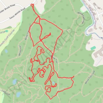
Name: Saxon Woods Park trail, distance, elevation, map, profile, GPS track
Coordinates: 40.98529 -73.75497 40.99187 -73.75085
Other hiking, mountain biking, running and outdoor activity trails
Click on a trail to view its statistics, map and profile.
Saxon Woods Park - Yellow and White trails loop
United States > New York > Westchester County > Village of Scarsdale
Distance: 3.2 mi • Elevation gain: 94 m • Maximum elevation: 64 m
Saxon Woods Loop Hike
United States > New York > Westchester County > Village of Scarsdale
Distance: 3.7 mi • Elevation gain: 30 m • Maximum elevation: 64 m