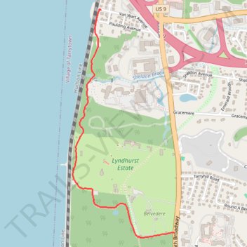
Westchester RiverWalk
- Distance: 1.5 mi
- Elevation gain: 90 m
- Maximum elevation: 71 m
- Elevation loss: 30 m
- Minimum elevation: 6 m
- Moving time: 33 m 24 s
- Moving speed: 2.6 mph
- Maximum speed: 4.1 mph
- Total time: 38 m 49 s
- Global speed: 2.3 mph
Interactive trail map
Trail profile
- Distance: 1.5 mi
- Elevation gain: 90 m
- Maximum elevation: 71 m
- Elevation loss: 30 m
- Minimum elevation: 6 m
- Moving time: 33 m 24 s
- Moving speed: 2.6 mph
- Maximum speed: 4.1 mph
- Total time: 38 m 49 s
- Global speed: 2.3 mph
About this trail
Name: Westchester RiverWalk trail, distance, elevation, map, profile, GPS track
Coordinates: 41.04980 -73.86979 41.06431 -73.86128
Other hiking, mountain biking, running and outdoor activity trails
Click on a trail to view its statistics, map and profile.
Old Croton Aqueduct Trail and Bronx
United States > New York > Westchester County > Village of Croton-on-Hudson
Distance: 44.0 mi • Elevation gain: 823 m • Maximum elevation: 80 m