Make a donation
Gear up for your next adventure:
As an Amazon Associate, this site earns from qualifying purchases at no extra cost to you.
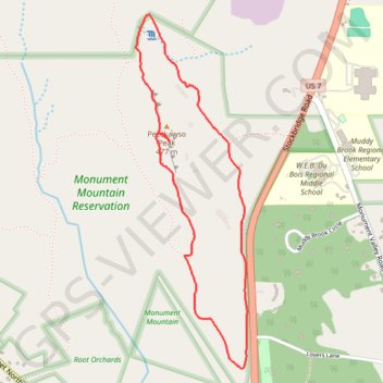
Devil's Pulpit Overlook Loop via Hickey Trail, Peeskawso Peak Trail and Mohican Monument Trail in Monument Mountain Reservation
The Devil's Pulpit Overlook Loop on Monument Mountain offers a moderately challenging hike rich in both natural beauty and historical significance. Combining the Hickey Trail, Peeskawso Peak Trail, and Mohican Monument Trail, the loop winds through dense forest, revealing ancient quartzite rock formations and breathtaking overlooks with views stretching across the Berkshires and beyond to the Catskill Mountains. The hike culminates at the iconic Devil's Pulpit, a striking rock outcropping with a steep drop, making this trail a memorable choice for hikers seeking a blend of rugged terrain and panoramic vistas. #Hiking #Loop #Rock #Forest #Nature
- Distance: 2.5 mi
- Elevation gain: 205 m
- Maximum elevation: 464 m
- Elevation loss: 207 m
- Minimum elevation: 292 m
- Moving time: 1 h 30 m
- Moving speed: 1.7 mph
- Maximum speed: 3.9 mph
- Total time: 1 h 46 m
- Global speed: 1.4 mph
Interactive trail map
Make a donation
Gear up for your next adventure:
As an Amazon Associate, this site earns from qualifying purchases at no extra cost to you.
Trail profile
- Distance: 2.5 mi
- Elevation gain: 205 m
- Maximum elevation: 464 m
- Elevation loss: 207 m
- Minimum elevation: 292 m
- Moving time: 1 h 30 m
- Moving speed: 1.7 mph
- Maximum speed: 3.9 mph
- Total time: 1 h 46 m
- Global speed: 1.4 mph
Make a donation
Gear up for your next adventure:
As an Amazon Associate, this site earns from qualifying purchases at no extra cost to you.
About this trail
Name: Devil's Pulpit Overlook Loop via Hickey Trail, Peeskawso Peak Trail and Mohican Monument Trail in Monument Mountain Reservation trail, distance, elevation, map, profile, GPS track
Coordinates: 42.23693 -73.34158 42.25207 -73.33517
Make a donation
Gear up for your next adventure:
As an Amazon Associate, this site earns from qualifying purchases at no extra cost to you.
Other hiking, mountain biking, running and outdoor activity trails
Click on a trail to view its statistics, map and profile.