Make a donation
Gear up for your next adventure:
As an Amazon Associate, this site earns from qualifying purchases at no extra cost to you.
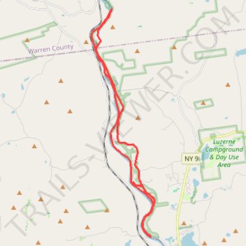
Hudson paddle and wheel - Hadley to Luzerne
- Distance: 15.6 mi
- Elevation gain: 185 m
- Maximum elevation: 207 m
- Elevation loss: 185 m
- Minimum elevation: 171 m
- Moving time: 4 h 28 m
- Moving speed: 3.5 mph
- Maximum speed: 7.8 mph
- Total time: 5 h 7 m
- Global speed: 3.0 mph
Interactive trail map
Make a donation
Gear up for your next adventure:
As an Amazon Associate, this site earns from qualifying purchases at no extra cost to you.
Trail profile
- Distance: 15.6 mi
- Elevation gain: 185 m
- Maximum elevation: 207 m
- Elevation loss: 185 m
- Minimum elevation: 171 m
- Moving time: 4 h 28 m
- Moving speed: 3.5 mph
- Maximum speed: 7.8 mph
- Total time: 5 h 7 m
- Global speed: 3.0 mph
Make a donation
Gear up for your next adventure:
As an Amazon Associate, this site earns from qualifying purchases at no extra cost to you.
About this trail
Name: Hudson paddle and wheel - Hadley to Luzerne trail, distance, elevation, map, profile, GPS track
Start: River Road, Town of Warrensburg, Warren County, New York, United States (43.41309 -73.87424)
End: River Road, Town of Warrensburg, Warren County, New York, United States (43.41309 -73.87427)
Coordinates: 43.32553 -73.88514 43.41324 -73.85179
Make a donation
Gear up for your next adventure:
As an Amazon Associate, this site earns from qualifying purchases at no extra cost to you.
Other hiking, mountain biking, running and outdoor activity trails
Click on a trail to view its statistics, map and profile.