Cascade Mountain Trail in High Peaks Wilderness
The Cascade Mountain Trail in the Adirondacks offers hikers a moderately challenging ascent through dense forests, leading to a bald summit with panoramic views of the surrounding High Peaks. Along the route, hikers can observe the diverse flora of the Adirondack Park and, upon reaching the summit, enjoy vistas that include neighboring peaks such as Porter Mountain, as well as distant vistas of Lake Placid and the Green Mountains in Vermont. The trail's popularity is well-deserved, providing a rewarding experience for those seeking a quintessential Adirondack hike. #Hiking #Mountain #Forest #Nature #Overlook
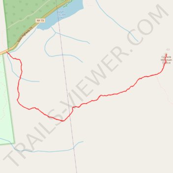
- Distance: 4.5 mi
- Elevation gain: 565 m
- Maximum elevation: 1,226 m
- Elevation loss: 565 m
- Minimum elevation: 661 m
- Moving time: 2 h 26 m
- Moving speed: 1.8 mph
- Maximum speed: 4.1 mph
- Total time: 3 h 24 m
- Global speed: 1.3 mph
Interactive trail map
Trail profile
- Distance: 4.5 mi
- Elevation gain: 565 m
- Maximum elevation: 1,226 m
- Elevation loss: 565 m
- Minimum elevation: 661 m
- Moving time: 2 h 26 m
- Moving speed: 1.8 mph
- Maximum speed: 4.1 mph
- Total time: 3 h 24 m
- Global speed: 1.3 mph
About this trail
Name: Cascade Mountain Trail in High Peaks Wilderness trail, distance, elevation, map, profile, GPS track
Coordinates: 44.21032 -73.88766 44.21887 -73.86015
Other hiking, mountain biking, running and outdoor activity trails
Click on a trail to view its statistics, map and profile.
Cascade Mountain Trail to Cascade Mountain and Porter Mountain in High Peaks Wilderness
United States > New York > Essex County > Town of Keene
The hike along the Cascade Mountain Trail to both Cascade and Porter Mountains offers a rewarding experience with breathtaking views of the surrounding Adirondack peaks and Lake Champlain. The well-maintained trail features a gradual ascent with rocky sections that culminate in stunning panoramic vistas from…
Distance: 6.0 mi • Elevation gain: 668 m • Maximum elevation: 1,226 m
Cascade Mountain and Porter Mountain
United States > New York > Essex County > Town of Keene
High Peaks Wilderness. #Hiking #Snowshoeing #Mountain #Forest #Nature
Distance: 5.7 mi • Elevation gain: 671 m • Maximum elevation: 1,225 m