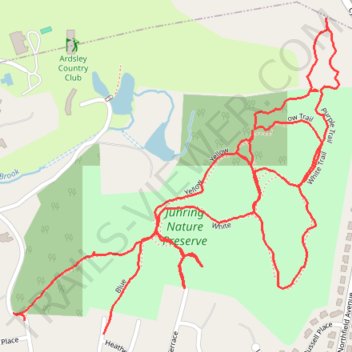
Juhring Nature Preserve trails
- Distance: 2.5 mi
- Elevation gain: 52 m
- Maximum elevation: 117 m
- Elevation loss: 58 m
- Minimum elevation: 95 m
- Moving time: 45 m 33 s
- Moving speed: 3.2 mph
- Maximum speed: 6.9 mph
- Total time: 47 m 21 s
- Global speed: 3.1 mph
Interactive trail map
Trail profile
- Distance: 2.5 mi
- Elevation gain: 52 m
- Maximum elevation: 117 m
- Elevation loss: 58 m
- Minimum elevation: 95 m
- Moving time: 45 m 33 s
- Moving speed: 3.2 mph
- Maximum speed: 6.9 mph
- Total time: 47 m 21 s
- Global speed: 3.1 mph
About this trail
Name: Juhring Nature Preserve trails trail, distance, elevation, map, profile, GPS track
Coordinates: 41.01794 -73.85745 41.02433 -73.84872
Other hiking, mountain biking, running and outdoor activity trails
Click on a trail to view its statistics, map and profile.
Old Croton Aqueduct Trail and Bronx
United States > New York > Westchester County > Village of Croton-on-Hudson
Distance: 44.0 mi • Elevation gain: 823 m • Maximum elevation: 80 m