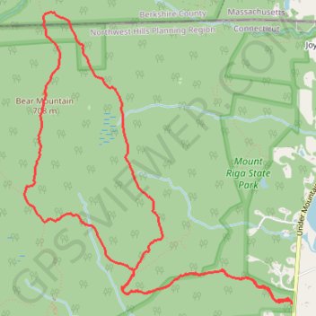
Bear Mountain Loop Trail in Mount Riga State Park
The Bear Mountain Loop Trail offers a delightful hiking experience characterized by its diverse terrain and stunning vistas. Hikers can enjoy the rugged beauty of rock scrambles leading to the summit, where the remnants of a historic stone tower provide a picturesque backdrop for breathtaking views of the surrounding mountains and valleys. Along the way, the trail features lush forests, wildlife sightings, and the chance to encounter wild blueberries, making it a rewarding adventure for outdoor enthusiasts. #Hiking #Loop #Mountain #Forest #Nature
- Distance: 6.2 mi
- Elevation gain: 479 m
- Maximum elevation: 701 m
- Elevation loss: 477 m
- Minimum elevation: 234 m
- Moving time: 2 h 43 m
- Moving speed: 2.3 mph
- Maximum speed: 5.7 mph
- Total time: 3 h 6 m
- Global speed: 2.0 mph
Interactive trail map
Trail profile
- Distance: 6.2 mi
- Elevation gain: 479 m
- Maximum elevation: 701 m
- Elevation loss: 477 m
- Minimum elevation: 234 m
- Moving time: 2 h 43 m
- Moving speed: 2.3 mph
- Maximum speed: 5.7 mph
- Total time: 3 h 6 m
- Global speed: 2.0 mph
About this trail
Name: Bear Mountain Loop Trail in Mount Riga State Park trail, distance, elevation, map, profile, GPS track
Coordinates: 42.02867 -73.45674 42.05118 -73.42892
Other hiking, mountain biking, running and outdoor activity trails
Click on a trail to view its statistics, map and profile.