Import a GPX file

Hurricane Mountain

Hike to the Hurricane Mountain in the Hurricane Mountain Wilderness. #Hiking #Mountain #Nature #Forest #Wilderness
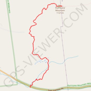
  • Distance: 3.2 mi
  • Elevation gain: 588 m
  • Maximum elevation: 1,103 m
  • Elevation loss: 8 m
  • Minimum elevation: 521 m

Interactive trail map

Trail profile

  • Distance: 3.2 mi
  • Elevation gain: 588 m
  • Maximum elevation: 1,103 m
  • Elevation loss: 8 m
  • Minimum elevation: 521 m

About this trail

Other hiking, mountain biking, running and outdoor activity trails

Click on a trail to view its statistics, map and profile.

Québec - Montréal - Saint-Laurent River - Lake Ontario - Niagara Falls

Canada > Quebec > Urban agglomeration of Québec > Quebec

#Bike #Ontario

Distance: 670.1 mi • Elevation gain: 4,804 m • Maximum elevation: 209 m

Montréal - New York

Canada > Quebec > Urban agglomeration of Montreal > Montreal

#Bike #Montréal #NewYork

Distance: 396.2 mi • Elevation gain: 4,860 m • Maximum elevation: 301 m

Gear up for your next adventure:

🗺️Ordnance Survey Maps - Essential paper maps for hiking across the UK national parks
👟Women's Trail Running Shoes - Agile footwear for fell running and technical trails
🧵Survival Paracord - Multi-purpose cordage for emergency repairs and shelters
🧘Folding Sit Mats - Dry and warm seat for map-reading breaks on damp ground
🧊Insulated Flasks - Keeps drinks hot or cold during hikes

As an Amazon Associate, this site earns from qualifying purchases at no extra cost to you.