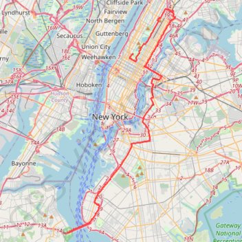
New York City Marathon
Interactive trail map
Trail profile
- Distance: 26.9 mi
- Elevation gain: 389 m
- Maximum elevation: 45 m
- Elevation loss: 394 m
- Minimum elevation: -4 m
About this trail
Name: New York City Marathon trail, distance, elevation, map, profile, GPS track
End: Warner LeRoy Place, Manhattan, New York County, New York, 10023, United States (40.77269 -73.97667)
Coordinates: 40.60215 -74.05954 40.81479 -73.92439
Other hiking, mountain biking, running and outdoor activity trails
Click on a trail to view its statistics, map and profile.
Forever drawn in by the mystique of Kearny Point
United States > New Jersey > Hudson County > Jersey City
bike ride
Distance: 18.4 mi • Elevation gain: 201 m • Maximum elevation: 35 m
Old Croton Aqueduct Trail and Bronx
United States > New York > Westchester County > Village of Croton-on-Hudson
Distance: 44.0 mi • Elevation gain: 823 m • Maximum elevation: 80 m
Central Park Evening walk
United States > New York > New York County > New York
Distance: 2.4 mi • Elevation gain: 69 m • Maximum elevation: 49 m
Liberty State Park
United States > New Jersey > Hudson County > Jersey City > Communipaw
Distance: 4.3 mi • Elevation gain: 16 m • Maximum elevation: 5 m
Morning Run
United States > New York > New York County > New York
Distance: 8.5 mi • Elevation gain: 158 m • Maximum elevation: 34 m
New
United States > New York > New York County > New York
Distance: 55.0 mi • Elevation gain: 1,435 m • Maximum elevation: 63 m