Thank you for supporting this site ❤️
Make a donation
Make a donation
Gear up for your next adventure:
As an Amazon Associate, this site earns from qualifying purchases at no extra cost to you.
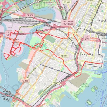
Forever drawn in by the mystique of Kearny Point
bike ride
- Distance: 18.4 mi
- Elevation gain: 201 m
- Maximum elevation: 35 m
- Elevation loss: 194 m
- Minimum elevation: -3 m
- Moving time: 1 h 24 m
- Moving speed: 13.1 mph
- Maximum speed: 26.5 mph
- Total time: 1 h 49 m
- Global speed: 10.1 mph
Interactive trail map
Thank you for supporting this site ❤️
Make a donation
Make a donation
Gear up for your next adventure:
As an Amazon Associate, this site earns from qualifying purchases at no extra cost to you.
Trail profile
- Distance: 18.4 mi
- Elevation gain: 201 m
- Maximum elevation: 35 m
- Elevation loss: 194 m
- Minimum elevation: -3 m
- Moving time: 1 h 24 m
- Moving speed: 13.1 mph
- Maximum speed: 26.5 mph
- Total time: 1 h 49 m
- Global speed: 10.1 mph
Thank you for supporting this site ❤️
Make a donation
Make a donation
Gear up for your next adventure:
As an Amazon Associate, this site earns from qualifying purchases at no extra cost to you.
About this trail
Name: Forever drawn in by the mystique of Kearny Point trail, distance, elevation, map, profile, GPS track
Coordinates: 40.70637 -74.11833 40.73708 -74.03320
Thank you for supporting this site ❤️
Make a donation
Make a donation
Gear up for your next adventure:
As an Amazon Associate, this site earns from qualifying purchases at no extra cost to you.
Other hiking, mountain biking, running and outdoor activity trails
Click on a trail to view its statistics, map and profile.
Liberty State Park
United States > New Jersey > Hudson County > Jersey City > Communipaw
Distance: 4.3 mi • Elevation gain: 16 m • Maximum elevation: 5 m