Gedney Park Central
- Distance: 1.2 mi
- Elevation gain: 26 m
- Maximum elevation: 134 m
- Elevation loss: 26 m
- Minimum elevation: 121 m
- Moving time: 33 m 15 s
- Moving speed: 2.1 mph
- Maximum speed: 4.4 mph
- Total time: 44 m 22 s
- Global speed: 1.6 mph
Interactive trail map
Trail profile
- Distance: 1.2 mi
- Elevation gain: 26 m
- Maximum elevation: 134 m
- Elevation loss: 26 m
- Minimum elevation: 121 m
- Moving time: 33 m 15 s
- Moving speed: 2.1 mph
- Maximum speed: 4.4 mph
- Total time: 44 m 22 s
- Global speed: 1.6 mph
About this trail
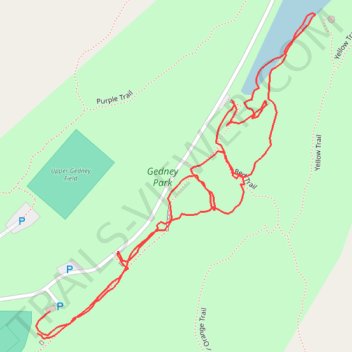
Name: Gedney Park Central trail, distance, elevation, map, profile, GPS track
Coordinates: 41.18234 -73.79810 41.18647 -73.79339
Other hiking, mountain biking, running and outdoor activity trails
Click on a trail to view its statistics, map and profile.
Gedney Park East
United States > New York > Westchester County > Millwood
Distance: 2.0 mi • Elevation gain: 53 m • Maximum elevation: 146 m
Gedney Park West
United States > New York > Westchester County > Millwood
Distance: 2.4 mi • Elevation gain: 119 m • Maximum elevation: 170 m