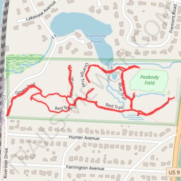
Peabody Preserve Outdoor Classroom trails
- Distance: 1.9 mi
- Elevation gain: 40 m
- Maximum elevation: 21 m
- Elevation loss: 41 m
- Minimum elevation: 7 m
- Moving time: 39 m 42 s
- Moving speed: 2.9 mph
- Maximum speed: 4.5 mph
- Total time: 40 m 36 s
- Global speed: 2.8 mph
Interactive trail map
Trail profile
- Distance: 1.9 mi
- Elevation gain: 40 m
- Maximum elevation: 21 m
- Elevation loss: 41 m
- Minimum elevation: 7 m
- Moving time: 39 m 42 s
- Moving speed: 2.9 mph
- Maximum speed: 4.5 mph
- Total time: 40 m 36 s
- Global speed: 2.8 mph
About this trail
Name: Peabody Preserve Outdoor Classroom trails trail, distance, elevation, map, profile, GPS track
Coordinates: 41.09941 -73.86914 41.10109 -73.86173
Other hiking, mountain biking, running and outdoor activity trails
Click on a trail to view its statistics, map and profile.
Old Croton Aqueduct Trail and Bronx
United States > New York > Westchester County > Village of Croton-on-Hudson
Distance: 44.0 mi • Elevation gain: 823 m • Maximum elevation: 80 m