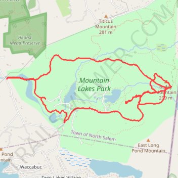
Mountain Lakes Park loop
- Distance: 6.0 mi
- Elevation gain: 248 m
- Maximum elevation: 298 m
- Elevation loss: 248 m
- Minimum elevation: 159 m
- Moving time: 1 h 50 m
- Moving speed: 3.3 mph
- Maximum speed: 5.7 mph
- Total time: 2 h 2 m
- Global speed: 2.9 mph
Interactive trail map
Trail profile
- Distance: 6.0 mi
- Elevation gain: 248 m
- Maximum elevation: 298 m
- Elevation loss: 248 m
- Minimum elevation: 159 m
- Moving time: 1 h 50 m
- Moving speed: 3.3 mph
- Maximum speed: 5.7 mph
- Total time: 2 h 2 m
- Global speed: 2.9 mph
About this trail
Name: Mountain Lakes Park loop trail, distance, elevation, map, profile, GPS track
Coordinates: 41.30639 -73.58066 41.31578 -73.55026
Other hiking, mountain biking, running and outdoor activity trails
Click on a trail to view its statistics, map and profile.
Halmi Preserve and Hearst Mead Preserve trails
United States > New York > Westchester County > Town of North Salem > Grant Corner
Distance: 3.6 mi • Elevation gain: 176 m • Maximum elevation: 224 m
Mountain Lakes Park trails
United States > New York > Westchester County > Town of North Salem
Distance: 5.9 mi • Elevation gain: 250 m • Maximum elevation: 277 m