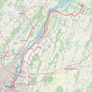
Pierreville - Leclercville
#Bike #Pierreville #Leclercville #Atlantic
- Distance: 75.1 mi
- Elevation gain: 324 m
- Maximum elevation: 36 m
- Elevation loss: 349 m
- Minimum elevation: 6 m
Interactive trail map
Trail profile
- Distance: 75.1 mi
- Elevation gain: 324 m
- Maximum elevation: 36 m
- Elevation loss: 349 m
- Minimum elevation: 6 m
About this trail
Name: Pierreville - Leclercville trail, distance, elevation, map, profile, GPS track
Coordinates: 45.48550 -73.57321 46.09294 -72.81434
Other hiking, mountain biking, running and outdoor activity trails
Click on a trail to view its statistics, map and profile.
East Hawkesbury - Montréal
Canada > Ontario > Prescott and Russell Counties > East Hawkesbury
#Bike #EastHawkesbury #Montréal
Distance: 56.8 mi • Elevation gain: 393 m • Maximum elevation: 91 m
Salaberry-de-Valleyfield - Montréal
Canada > Quebec > Beauharnois-Salaberry > Salaberry-de-Valleyfield
#Bike
Distance: 55.9 mi • Elevation gain: 363 m • Maximum elevation: 70 m
Lanoraie - Trois-Rivières
Canada > Quebec > D'Autray > Lanoraie
Saint Lawrence River. #Bike #Lanoraie #TroisRivières #SaintLawrence
Distance: 44.4 mi • Elevation gain: 122 m • Maximum elevation: 21 m
Berthierville - Trois-Rivières
Canada > Quebec > D'Autray > Berthierville
#Bike
Distance: 45.2 mi • Elevation gain: 161 m • Maximum elevation: 41 m
Montréal - Lanoraie
Canada > Quebec > Urban agglomeration of Montreal > Montreal
Saint Lawrence River. #Bike #Montréal #Lanoraie #SaintLawrence
Distance: 43.6 mi • Elevation gain: 181 m • Maximum elevation: 52 m
Montréal - Berthierville
Canada > Quebec > Urban agglomeration of Montreal > Montreal
#Bike
Distance: 44.2 mi • Elevation gain: 133 m • Maximum elevation: 41 m
Circuit Violet
Canada > Quebec > Matawinie > Rawdon
Distance: 59.3 mi • Elevation gain: 942 m • Maximum elevation: 273 m