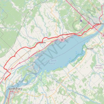
Berthierville - Trois-Rivières
#Bike
- Distance: 45.2 mi
- Elevation gain: 161 m
- Maximum elevation: 41 m
- Elevation loss: 162 m
- Minimum elevation: 6 m
Interactive trail map
Trail profile
- Distance: 45.2 mi
- Elevation gain: 161 m
- Maximum elevation: 41 m
- Elevation loss: 162 m
- Minimum elevation: 6 m
About this trail
Name: Berthierville - Trois-Rivières trail, distance, elevation, map, profile, GPS track
Coordinates: 46.08299 -73.19243 46.34032 -72.55219
Other hiking, mountain biking, running and outdoor activity trails
Click on a trail to view its statistics, map and profile.
Pierreville - Leclercville
Canada > Quebec > Urban agglomeration of Montreal > Montreal
#Bike #Pierreville #Leclercville #Atlantic
Distance: 75.1 mi • Elevation gain: 324 m • Maximum elevation: 36 m
Lanoraie - Trois-Rivières
Canada > Quebec > D'Autray > Lanoraie
Saint Lawrence River. #Bike #Lanoraie #TroisRivières #SaintLawrence
Distance: 44.4 mi • Elevation gain: 122 m • Maximum elevation: 21 m
Montréal - Berthierville
Canada > Quebec > Urban agglomeration of Montreal > Montreal
#Bike
Distance: 44.2 mi • Elevation gain: 133 m • Maximum elevation: 41 m
Trois-Rivières - Québec
Canada > Quebec > Trois-Rivières
#Bike
Distance: 86.0 mi • Elevation gain: 838 m • Maximum elevation: 108 m