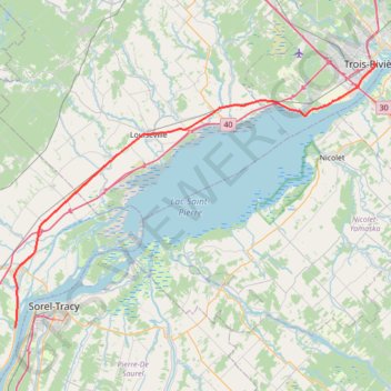
Lanoraie - Trois-Rivières
Saint Lawrence River. #Bike #Lanoraie #TroisRivières #SaintLawrence
- Distance: 44.4 mi
- Elevation gain: 122 m
- Maximum elevation: 21 m
- Elevation loss: 114 m
- Minimum elevation: 5 m
Interactive trail map
Trail profile
- Distance: 44.4 mi
- Elevation gain: 122 m
- Maximum elevation: 21 m
- Elevation loss: 114 m
- Minimum elevation: 5 m
About this trail
Name: Lanoraie - Trois-Rivières trail, distance, elevation, map, profile, GPS track
Start: Grande Côte Est, Lanoraie, D'Autray, Lanaudière, Quebec, J3R 5M7, Canada (46.01659 -73.18541)
End: 501, Rue Radisson, Trois-Rivières, Mauricie, Quebec, G9A 2C7, Canada (46.34369 -72.54498)
Coordinates: 46.01659 -73.18609 46.34369 -72.54003
Other hiking, mountain biking, running and outdoor activity trails
Click on a trail to view its statistics, map and profile.
Trois-Rivières - Portneuf
Canada > Quebec > Trois-Rivières
Saint Lawrence River. #Bike #TroisRivières #Portneuf #SaintLawrence
Distance: 42.0 mi • Elevation gain: 211 m • Maximum elevation: 44 m
Pierreville - Leclercville
Canada > Quebec > Urban agglomeration of Montreal > Montreal
#Bike #Pierreville #Leclercville #Atlantic
Distance: 75.1 mi • Elevation gain: 324 m • Maximum elevation: 36 m
Berthierville - Trois-Rivières
Canada > Quebec > D'Autray > Berthierville
#Bike
Distance: 45.2 mi • Elevation gain: 161 m • Maximum elevation: 41 m
Montréal - Lanoraie
Canada > Quebec > Urban agglomeration of Montreal > Montreal
Saint Lawrence River. #Bike #Montréal #Lanoraie #SaintLawrence
Distance: 43.6 mi • Elevation gain: 181 m • Maximum elevation: 52 m
Montréal - Berthierville
Canada > Quebec > Urban agglomeration of Montreal > Montreal
#Bike
Distance: 44.2 mi • Elevation gain: 133 m • Maximum elevation: 41 m
Trois-Rivières - Québec
Canada > Quebec > Trois-Rivières
#Bike
Distance: 86.0 mi • Elevation gain: 838 m • Maximum elevation: 108 m