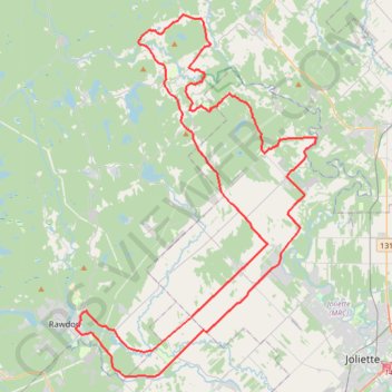
Circuit Violet
- Distance: 59.3 mi
- Elevation gain: 942 m
- Maximum elevation: 273 m
- Elevation loss: 942 m
- Minimum elevation: 57 m
Interactive trail map
Trail profile
- Distance: 59.3 mi
- Elevation gain: 942 m
- Maximum elevation: 273 m
- Elevation loss: 942 m
- Minimum elevation: 57 m
About this trail
Name: Circuit Violet trail, distance, elevation, map, profile, GPS track
Start: 3555, Rue Metcalfe, Rawdon, Matawinie, Lanaudière, Quebec, J0K 1S0, Canada (46.04194 -73.70089)
End: 3338, 3e Avenue, Rawdon, Matawinie, Lanaudière, Quebec, J0K 1S0, Canada (46.04234 -73.70034)
Coordinates: 46.01181 -73.70089 46.23838 -73.48332
Other hiking, mountain biking, running and outdoor activity trails
Click on a trail to view its statistics, map and profile.
Pierreville - Leclercville
Canada > Quebec > Urban agglomeration of Montreal > Montreal
#Bike #Pierreville #Leclercville #Atlantic
Distance: 75.1 mi • Elevation gain: 324 m • Maximum elevation: 36 m
Montréal - Lanoraie
Canada > Quebec > Urban agglomeration of Montreal > Montreal
Saint Lawrence River. #Bike #Montréal #Lanoraie #SaintLawrence
Distance: 43.6 mi • Elevation gain: 181 m • Maximum elevation: 52 m
Montréal - Berthierville
Canada > Quebec > Urban agglomeration of Montreal > Montreal
#Bike
Distance: 44.2 mi • Elevation gain: 133 m • Maximum elevation: 41 m