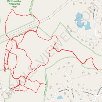
Hardscrabble Wilderness Area trails
- Distance: 5.3 mi
- Elevation gain: 203 m
- Maximum elevation: 159 m
- Elevation loss: 203 m
- Minimum elevation: 101 m
- Moving time: 1 h 40 m
- Moving speed: 3.2 mph
- Maximum speed: 6.0 mph
- Total time: 1 h 43 m
- Global speed: 3.1 mph
Interactive trail map
Trail profile
- Distance: 5.3 mi
- Elevation gain: 203 m
- Maximum elevation: 159 m
- Elevation loss: 203 m
- Minimum elevation: 101 m
- Moving time: 1 h 40 m
- Moving speed: 3.2 mph
- Maximum speed: 6.0 mph
- Total time: 1 h 43 m
- Global speed: 3.1 mph
About this trail
Name: Hardscrabble Wilderness Area trails trail, distance, elevation, map, profile, GPS track
Coordinates: 41.14297 -73.81153 41.15144 -73.79876
Other hiking, mountain biking, running and outdoor activity trails
Click on a trail to view its statistics, map and profile.