Thank you for supporting this site ❤️
Make a donation
Make a donation
Gear up for your next adventure:
As an Amazon Associate, this site earns from qualifying purchases at no extra cost to you.
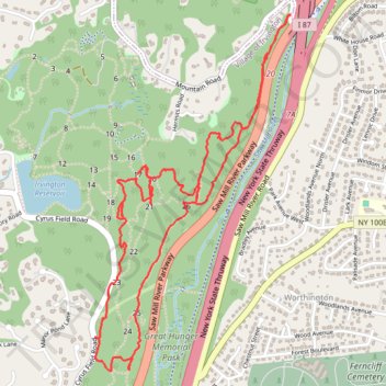
Irvington Woods South
- Distance: 3.9 mi
- Elevation gain: 189 m
- Maximum elevation: 135 m
- Elevation loss: 190 m
- Minimum elevation: 70 m
- Moving time: 1 h 16 m
- Moving speed: 3.1 mph
- Maximum speed: 5.6 mph
- Total time: 1 h 19 m
- Global speed: 3.0 mph
Interactive trail map
Thank you for supporting this site ❤️
Make a donation
Make a donation
Gear up for your next adventure:
As an Amazon Associate, this site earns from qualifying purchases at no extra cost to you.
Trail profile
- Distance: 3.9 mi
- Elevation gain: 189 m
- Maximum elevation: 135 m
- Elevation loss: 190 m
- Minimum elevation: 70 m
- Moving time: 1 h 16 m
- Moving speed: 3.1 mph
- Maximum speed: 5.6 mph
- Total time: 1 h 19 m
- Global speed: 3.0 mph
Thank you for supporting this site ❤️
Make a donation
Make a donation
Gear up for your next adventure:
As an Amazon Associate, this site earns from qualifying purchases at no extra cost to you.
About this trail
Name: Irvington Woods South trail, distance, elevation, map, profile, GPS track
Coordinates: 41.02770 -73.84796 41.04314 -73.83669
Thank you for supporting this site ❤️
Make a donation
Make a donation
Gear up for your next adventure:
As an Amazon Associate, this site earns from qualifying purchases at no extra cost to you.
Other hiking, mountain biking, running and outdoor activity trails
Click on a trail to view its statistics, map and profile.
Irvington Woods (West) Track
United States > New York > Westchester County > Village of Irvington
Distance: 5.2 mi • Elevation gain: 170 m • Maximum elevation: 145 m