Thank you for supporting this site ❤️
Make a donation
Make a donation
Gear up for your next adventure:
As an Amazon Associate, this site earns from qualifying purchases at no extra cost to you.
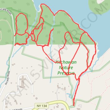
Kitchawan Nature Preserve trails
- Distance: 5.5 mi
- Elevation gain: 157 m
- Maximum elevation: 122 m
- Elevation loss: 157 m
- Minimum elevation: 65 m
- Moving time: 1 h 46 m
- Moving speed: 3.1 mph
- Maximum speed: 7.4 mph
- Total time: 1 h 57 m
- Global speed: 2.8 mph
Interactive trail map
Thank you for supporting this site ❤️
Make a donation
Make a donation
Gear up for your next adventure:
As an Amazon Associate, this site earns from qualifying purchases at no extra cost to you.
Trail profile
- Distance: 5.5 mi
- Elevation gain: 157 m
- Maximum elevation: 122 m
- Elevation loss: 157 m
- Minimum elevation: 65 m
- Moving time: 1 h 46 m
- Moving speed: 3.1 mph
- Maximum speed: 7.4 mph
- Total time: 1 h 57 m
- Global speed: 2.8 mph
Thank you for supporting this site ❤️
Make a donation
Make a donation
Gear up for your next adventure:
As an Amazon Associate, this site earns from qualifying purchases at no extra cost to you.
About this trail
Name: Kitchawan Nature Preserve trails trail, distance, elevation, map, profile, GPS track
Coordinates: 41.22058 -73.79472 41.23133 -73.78325
Thank you for supporting this site ❤️
Make a donation
Make a donation
Gear up for your next adventure:
As an Amazon Associate, this site earns from qualifying purchases at no extra cost to you.
Other hiking, mountain biking, running and outdoor activity trails
Click on a trail to view its statistics, map and profile.