Make a donation
Gear up for your next adventure:
As an Amazon Associate, this site earns from qualifying purchases at no extra cost to you.
Québec - Montréal - Saint-Laurent River - Lake Ontario - Niagara Falls
Interactive trail map
Make a donation
Gear up for your next adventure:
As an Amazon Associate, this site earns from qualifying purchases at no extra cost to you.
Trail profile
- Distance: 670.1 mi
- Elevation gain: 4,804 m
- Maximum elevation: 209 m
- Elevation loss: 4,632 m
- Minimum elevation: -1 m
Make a donation
Gear up for your next adventure:
As an Amazon Associate, this site earns from qualifying purchases at no extra cost to you.
About this trail
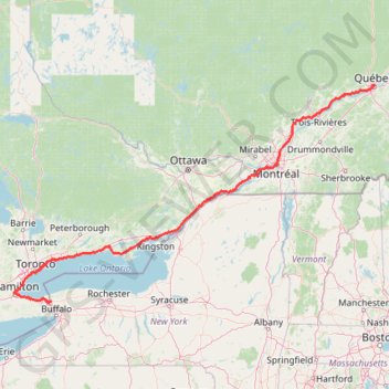
Name: Québec - Montréal - Saint-Laurent River - Lake Ontario - Niagara Falls trail, distance, elevation, map, profile, GPS track
Coordinates: 43.08778 -79.89248 46.82520 -71.19960
Make a donation
Gear up for your next adventure:
As an Amazon Associate, this site earns from qualifying purchases at no extra cost to you.
Other hiking, mountain biking, running and outdoor activity trails
Click on a trail to view its statistics, map and profile.
Brockville - Cornwall
Canada > Ontario > Brockville > Brockville
#Bike
Distance: 62.2 mi • Elevation gain: 298 m • Maximum elevation: 102 m
Make a donation
Gear up for your next adventure:
As an Amazon Associate, this site earns from qualifying purchases at no extra cost to you.
Haliburton Forest
Canada > Ontario > Haliburton County > Dysart et al
#Hiking #Loop #Haliburton
Distance: 4.2 mi • Elevation gain: 59 m • Maximum elevation: 417 m
Mount Washington, Lion Head and Tuckerman Ravine Loop
United States > New Hampshire > Coos County
Loop hike from Pinkham Notch to Mount Washington via Tuckerman Ravine Trail, Crystal Cascades Falls and Lion Head Trail in the Pinkham Notch Scenic Area, the Mount Washington State Park and the White Mountain National Forest. #Hiking #Loop #Mountain #Nature #Forest #Falls #Park
Distance: 7.8 mi • Elevation gain: 1,325 m • Maximum elevation: 1,911 m
Make a donation
Gear up for your next adventure:
As an Amazon Associate, this site earns from qualifying purchases at no extra cost to you.
Serena Gundy Park
Distance: 0.8 mi • Elevation gain: 29 m • Maximum elevation: 129 m
Make a donation
Gear up for your next adventure:
As an Amazon Associate, this site earns from qualifying purchases at no extra cost to you.
Little Haystack Mountain, Mount Lincoln and Mount Lafayette Loop
United States > New Hampshire > Grafton County > Lincoln
Loop hike from Franconia Notch via Falling Waters Trail, Stairs Falls, Swiftwater Falls, Cloudland Falls, Little Haystack Mountain, Franconia Ridge Trail, Mount Lincoln, Mount Lafayette, Greenleaf Trail, Greenleaf Hut and Old Bridle Path in the Franconia Notch State Park and the White Mountain National Forest.…
Distance: 8.1 mi • Elevation gain: 1,146 m • Maximum elevation: 1,582 m
Mount Skylight
United States > New York > Essex County
Hike to Mount Skylight via Adirondack Loj Road, Heart Lake, Van Hoevenberg Trail, Marcy Dam, Avalanche Pass Trail, Avalanche Camp, Lake Arnold Trail, Lake Arnold, Mount Marcy Trail, Lake Tear of the Clouds, Four Corners and Skylight Trail in the High Peaks Wilderness and the Adirondack Park. #Hiking #Mountain…
Distance: 20.5 mi • Elevation gain: 1,295 m • Maximum elevation: 1,492 m
Make a donation
Gear up for your next adventure:
As an Amazon Associate, this site earns from qualifying purchases at no extra cost to you.
Mount Pisgah via South Trail and Pulpit Rock in Willoughby State Forest
United States > Vermont > Orleans County > Westmore
The hike to Mount Pisgah is a rewarding journey with iconic views. As you ascend, Pulpit Rock provides a dramatic viewpoint perched hundreds of feet above the stunning Lake Willoughby, framed by the rugged cliffs of nearby Mount Hor. The summit reveals panoramic vistas that stretch across the Northeast…
Distance: 4.6 mi • Elevation gain: 710 m • Maximum elevation: 831 m
Mount Lafayette Loop via Franconia Ridge Trail in White Mountain National Forest
United States > New Hampshire > Grafton County > Lincoln
The Mount Lafayette Loop is a challenging and rewarding hike, offering some of the most stunning views in the region. Starting at the Falling Waters Trail, the hike begins with a steep ascent through the forest, passing several picturesque waterfalls. The real highlight, however, comes as you reach the…
Distance: 8.2 mi • Elevation gain: 1,118 m • Maximum elevation: 1,582 m
Bald Mountain and Artists Bluff Loop Trail in Franconia Notch State Park
United States > New Hampshire > Grafton County > Franconia
The Bald Mountain and Artists Bluff Loop Trail in Franconia Notch State Park offers hikers a rewarding experience with panoramic vistas. From the summit of Bald Mountain, enjoy expansive views of Echo Lake and the surrounding White Mountains. Continuing along the trail, Artists Bluff provides a unique vantage…
Distance: 1.5 mi • Elevation gain: 111 m • Maximum elevation: 696 m
Aldershot - Kitchener
Canada > Ontario > Halton Region > Burlington
#Bike
Distance: 49.1 mi • Elevation gain: 570 m • Maximum elevation: 346 m
Make a donation
Gear up for your next adventure:
As an Amazon Associate, this site earns from qualifying purchases at no extra cost to you.
Berthierville - Trois-Rivières
Canada > Quebec > D'Autray > Berthierville
#Bike
Distance: 45.2 mi • Elevation gain: 161 m • Maximum elevation: 41 m
Belleville - Kingston
Canada > Ontario > Belleville > Belleville
#Bike
Distance: 57.6 mi • Elevation gain: 394 m • Maximum elevation: 115 m
Cobourg - Belleville
Canada > Ontario > Northumberland County > Cobourg
#Bike
Distance: 50.6 mi • Elevation gain: 286 m • Maximum elevation: 118 m
Oshawa - Cobourg
Canada > Ontario > Durham Region > Oshawa
#Bike
Distance: 41.4 mi • Elevation gain: 453 m • Maximum elevation: 130 m
Make a donation
Gear up for your next adventure:
As an Amazon Associate, this site earns from qualifying purchases at no extra cost to you.
Toronto - Oshawa
Canada > Ontario > Old Toronto
#Bike
Distance: 41.8 mi • Elevation gain: 457 m • Maximum elevation: 183 m
Make a donation
Gear up for your next adventure:
As an Amazon Associate, this site earns from qualifying purchases at no extra cost to you.
Make a donation
Gear up for your next adventure:
As an Amazon Associate, this site earns from qualifying purchases at no extra cost to you.
Pierreville - Leclercville
Canada > Quebec > Urban agglomeration of Montreal > Montreal
#Bike #Pierreville #Leclercville #Atlantic
Distance: 75.1 mi • Elevation gain: 324 m • Maximum elevation: 36 m
Make a donation
Gear up for your next adventure:
As an Amazon Associate, this site earns from qualifying purchases at no extra cost to you.
Cobourg - Adolphustown
Canada > Ontario > Northumberland County > Cobourg
Lake Ontario. #Bike #Cobourg #Adolphustown #Ontario
Distance: 71.0 mi • Elevation gain: 449 m • Maximum elevation: 119 m
Make a donation
Gear up for your next adventure:
As an Amazon Associate, this site earns from qualifying purchases at no extra cost to you.
Lanoraie - Trois-Rivières
Canada > Quebec > D'Autray > Lanoraie
Saint Lawrence River. #Bike #Lanoraie #TroisRivières #SaintLawrence
Distance: 44.4 mi • Elevation gain: 122 m • Maximum elevation: 21 m
Mattawa - Stonecliffe
Canada > Ontario > Nipissing District > Mattawa
Distance: 45.8 mi • Elevation gain: 903 m • Maximum elevation: 318 m
Round Top - Sutton Trail
Canada > Quebec > Brome-Missisquoi > Sutton
Sutton Natural Environment Park. #Hiking #Snowshoeing #Sutton
Distance: 3.8 mi • Elevation gain: 422 m • Maximum elevation: 944 m
Make a donation
Gear up for your next adventure:
As an Amazon Associate, this site earns from qualifying purchases at no extra cost to you.
Arkon Lake Loop
Canada > Ontario > Frontenac County > South Frontenac
Frontenac Provincial Park. #Hiking #Snowshoeing #Loop #Frontenac
Distance: 6.1 mi • Elevation gain: 123 m • Maximum elevation: 191 m
Friday Harbour Nature Reserve
Canada > Ontario > Simcoe County > Innisfil
#Hiking #MTB #Snowshoeing #Loop #FridayHarbour
Distance: 2.9 mi • Elevation gain: 22 m • Maximum elevation: 241 m
Stoney Creek Loop
Stoney Creek Conservation Area. #Hiking #MTB #Running #Snowshoeing #Loop #StoneyCreek
Distance: 2.4 mi • Elevation gain: 19 m • Maximum elevation: 116 m
Make a donation
Gear up for your next adventure:
As an Amazon Associate, this site earns from qualifying purchases at no extra cost to you.
Bruce Trail from Guelph Line
Canada > Ontario > Halton Region > Burlington
Distance: 3.3 mi • Elevation gain: 119 m • Maximum elevation: 270 m
Make a donation
Gear up for your next adventure:
As an Amazon Associate, this site earns from qualifying purchases at no extra cost to you.
Big Slide Mountain Loop
United States > New York > Essex County > Town of Keene
Lop hike from Garden Parking to Big Slide Mountain via Phelps Trail, Big Slide Trail, The Brothers Trail, Third Brother, Second Brother and First Brother in the High Peaks Wilderness. #Hiking #Loop #Mountain #Nature #Wilderness
Distance: 9.0 mi • Elevation gain: 855 m • Maximum elevation: 1,252 m
Mount Chocorua and Middle Sister Loop
United States > New Hampshire > Carroll County > Albany
Loop hike to Mount Chocorua and Middle Sister via Piper Trail, Weetamoo Trail, Hammond Trail, Liberty Trail, Jim Liberty Cabin, Middle Sister Trail, Carter Ledge Trail and Nickerson Ledge Trail in the White Mountain National Forest and the Mount Chocorua Scenic Area. #Hiking #Loop #Mountain #Forest #Nature
Distance: 8.2 mi • Elevation gain: 824 m • Maximum elevation: 1,049 m
Mount Passaconaway and Mount Whiteface Loop
United States > New Hampshire > Carroll County > Ferncroft
Loop hike from Ferncroft to Mount Passaconaway via Ferncroft Road, Squirrel Bridge Road, Blueberry Ledge Trail, Rollins Trail, Dicey's Mill Trail, View Spur and Walden Trail in the Sandwich Range Wilderness, the Bowl Research Natural Area and the White Mountain National Forest. #Hiking #Loop #Mountain #Forest…
Distance: 11.7 mi • Elevation gain: 1,262 m • Maximum elevation: 1,226 m
Tripyramid Mountains Loop
United States > New Hampshire > Grafton County > Waterville Valley
Loop hike from Livermore South Trailhead to North Tripyramid, Middle Tripyramid and South Tripyramid via Livermore Road, Avalanche Brook, Mount Tripyramid Trail and Slide Brook in the Sandwich Range Wilderness. #Hiking #Loop #Mountain #Forest #Nature #Wilderness
Distance: 10.6 mi • Elevation gain: 854 m • Maximum elevation: 1,246 m
Make a donation
Gear up for your next adventure:
As an Amazon Associate, this site earns from qualifying purchases at no extra cost to you.
Seward Mountain, Donaldson Mountain, Seymour Mountain and Mount Emmons Loop
United States > New York > Franklin County > Town of Harrietstown
Loop hike to Seward Mountain via Blueberry Trail, Ward Brook Truck Trail, Seymour Trail, Seward Mountain Trail, Seward Range Trail and Calkins Brook Trail in the High Peaks Wilderness and the Adirondack Park. #Hiking #Loop #Mountain #Forest #Nature #Wilderness #Park
Distance: 20.5 mi • Elevation gain: 1,706 m • Maximum elevation: 1,318 m
Mount Marcy, Table Top and Phelps Mountain
United States > New York > Essex County
Hike from Heart Lake to Mount Marcy, Table Top and Phelps Mountain via Van Hoevenberg Trail, Marcy Dam, Phelps Mountain Trail, Indian Falls and Tabletop Mountain Trail in the High Peaks Wilderness and the Adirondacks Park. #Hiking #Mountain #Nature #Forest #Lake #Falls #River #Wilderness #Park
Distance: 18.3 mi • Elevation gain: 1,679 m • Maximum elevation: 1,612 m
Mount Redfield and Cliff Mountain
United States > New York > Essex County
Hike from Heart Lake to Mount Redfield and Cliff Mountain via Van Hoevenberg Trail, Marcy Dam, Avalanche Pass Trail, Avalanche Camp, Lake Arnold Trail, Lake Arnold, Mount Marcy Trail, Mount Redfield Trail and Cliff Mountain Trail in the High Peaks Wilderness and Adirondack Park. #Hiking #Mountain #Nature…
Distance: 18.5 mi • Elevation gain: 1,399 m • Maximum elevation: 1,388 m
Mount Isolation, North Isolation and Gulf Peak
United States > New Hampshire > Coos County
Hike to Mount Isolation via Glen Boulder Trail, Gulf Peak, Davis Path, North Isolation and Isolation Trail in the White Mountain National Forest, the Pinkham North Scenic Area and the Presidential Range-Dry River Wilderness. #Hiking #Mountain #Nature #Forest #Wilderness
Distance: 10.8 mi • Elevation gain: 1,411 m • Maximum elevation: 1,572 m
Make a donation
Gear up for your next adventure:
As an Amazon Associate, this site earns from qualifying purchases at no extra cost to you.
Dix Mountain Loop
United States > New York > Essex County > Town of Keene
Loop hike on the Dix Range via Boquet Forks Trail, Shoebox Falls, Lillypad Pond, Grace Peak, Grace Peak Trail, South Dix Lookout, South Dix, Dix Range Trail, Macomb Mountain, Hough Peak, Beckhorn Trail, Dix Mountain, Dix Trail and Round Pond in the High Peaks Wilderness and the Adirondack Park. #Hiking #Loop…
Distance: 16.8 mi • Elevation gain: 1,577 m • Maximum elevation: 1,456 m
Mount Marcy, Mount Skylight and Gray Peak
United States > New York > Essex County > Town of Keene
Return hike from Mount Marcy to Heart Lake via Mount Marcy Trail, Schofield Cobble, Four Corners, Skylight Trail, Lake Tear of the Clouds, Gray Peak Trail, Van Hoevenberg Trail, Indian Falls and Marcy Dam Pond in the High Peaks Wilderness and the Adirondack Park. #Hiking #Mountain #Nature #Forest #Lake #Falls…
Distance: 11.1 mi • Elevation gain: 607 m • Maximum elevation: 1,612 m
Mount Colden Loop
United States > New York > Essex County
Loop hike from Heart Lake to Mount Colden via Van Hoevenberg Trail, Marcy Dam Pond, Avalanche Pass Trail, Avalanche Pass, Avalanche Lake, Lake Colden, Mount Colden Trail, L. Morgan Porter Trail, Lake Arnold and Lake Arnold Trail in the High Peaks Wilderness and the Adirondack Park. #Hiking #Loop #Mountain…
Distance: 13.5 mi • Elevation gain: 1,000 m • Maximum elevation: 1,415 m
Giant Mountain and Rocky Peak Ridge
United States > New York > Essex County > Town of Keene
Hike from Chapel Pond to Giant Mountain and Rocky Peak Ridge via Ridge Trail, Ridge Lookout, Giant Washbowl, Roaring Brook Trail, East Trail and Giant East Slide Lookout in the Giant Mountain Wilderness and Adirondack Park. #Hiking #Mountain #Nature #Forest #Lake #Park #Wilderness
Distance: 8.2 mi • Elevation gain: 1,336 m • Maximum elevation: 1,387 m
Make a donation
Gear up for your next adventure:
As an Amazon Associate, this site earns from qualifying purchases at no extra cost to you.
Allen Mountain
United States > New York > Essex County > Town of Newcomb
Hike / snowshoes from East River Parking to Allen Mountain via East River Trail, Hudson River, Lake Jimmy, Lake Sally, Allen Mountain Trail and Allen Lookout North in the High Peaks Wilderness and the Adirondack Park. #Hiking #Snowshoeing #Mountain #Nature #Forest #Lake #River #Park #Wilderness #Adirondack
Distance: 17.8 mi • Elevation gain: 1,060 m • Maximum elevation: 1,302 m
Cascade Mountain Trail to Cascade Mountain and Porter Mountain in High Peaks Wilderness
United States > New York > Essex County > Town of Keene
The hike along the Cascade Mountain Trail to both Cascade and Porter Mountains offers a rewarding experience with breathtaking views of the surrounding Adirondack peaks and Lake Champlain. The well-maintained trail features a gradual ascent with rocky sections that culminate in stunning panoramic vistas from…
Distance: 6.0 mi • Elevation gain: 668 m • Maximum elevation: 1,226 m
Camel's Hump Loop via Forest City Trail, Long Trail and Burrows Trail
United States > Vermont > Chittenden County > Huntington
The Camel’s Hump Loop offers hikers a rewarding climb through dense forests, rugged alpine terrain, and open summit views. Starting on the Forest City Trail, hikers pass remnants of a Civilian Conservation Corps camp before joining the Long Trail, where views open up to showcase Vermont’s high peaks, the…
Distance: 5.6 mi • Elevation gain: 699 m • Maximum elevation: 1,223 m
Camel's Hump via Burrows Trail in Camel's Hump State Park
United States > Vermont > Chittenden County > Huntington
The Burrows Trail leading to Camel's Hump offers a captivating hike through diverse landscapes, starting in a protected forest with serene streams and birdsong. As you ascend, the trail becomes steeper, weaving through birch and spruce forests that gradually give way to stunning, expansive views once you near…
Distance: 4.9 mi • Elevation gain: 679 m • Maximum elevation: 1,223 m
Make a donation
Gear up for your next adventure:
As an Amazon Associate, this site earns from qualifying purchases at no extra cost to you.
Stowe Pinnacle Trail in C.C. Putnam State Forest
United States > Vermont > Lamoille County > Stowe
The Stowe Pinnacle Trail offers an invigorating hike through a lush Vermont forest, leading to a rocky summit with expansive 360-degree views. From the peak, you can observe distant mountains like Camel’s Hump and Mount Mansfield, along with the sweeping Worcester Range. The trail is a mix of steep, rocky…
Distance: 3.4 mi • Elevation gain: 458 m • Maximum elevation: 783 m
The Chin of Mount Mansfield via Sunset Ridge Trail in Underhill State Park
United States > Vermont > Chittenden County > Underhill
The Sunset Ridge Trail to the summit of Mount Mansfield provides a challenging and rewarding hiking experience, offering expansive views of Vermont’s landscape. As you ascend through dense forests and rocky stretches, the trail opens up to panoramic vistas, where you can catch sight of distant valleys and…
Distance: 6.0 mi • Elevation gain: 801 m • Maximum elevation: 1,332 m
Stowe Pinnacle Trail via Pinnacle Meadow in C.C. Putnam State Forest
United States > Vermont > Lamoille County > Stowe
The Stowe Pinnacle Trail is a moderately challenging hike offering beautiful views of Vermont's Green Mountains. As hikers ascend through dense forests, the route rewards with striking vistas of Mount Mansfield, Camel's Hump, and the Worcester Range from the summit's rocky outcrop. The last stretch becomes…
Distance: 3.4 mi • Elevation gain: 319 m • Maximum elevation: 783 m
Sterling Pond Trail and Top of the Notch in Mount Mansfield State Forest
United States > Vermont > Lamoille County > Cambridge
The Sterling Pond Trail offers an engaging hike through a varied landscape. Along the way, hikers are treated to a rich diversity of plant life, especially as they pass into the cool, high-elevation spruce-fir forests. At Sterling Pond itself, the scenery is spectacular, with expansive views across the water…
Distance: 2.5 mi • Elevation gain: 284 m • Maximum elevation: 928 m
Make a donation
Gear up for your next adventure:
As an Amazon Associate, this site earns from qualifying purchases at no extra cost to you.
Lye Brook Falls Trail in Green Mountain National Forest
United States > Vermont > Bennington County > Manchester Center > Manchester
The Lye Brook Falls Trail in Vermont provides a refreshing, immersive experience in the Green Mountain National Forest. The hike is mostly through a tranquil forest of hardwoods, with seasonal variations enhancing the scenery, from wildflowers in spring to vibrant fall colors. Along the way, you'll cross…
Distance: 4.5 mi • Elevation gain: 309 m • Maximum elevation: 504 m
Mount Mansfield Loop via Maple Ridge Trail, Long Trail and Sunset Ridge Trail
United States > Vermont > Chittenden County > Underhill
The Mount Mansfield Loop provides a challenging but rewarding hike to the highest peak in Vermont. As you climb, the varied terrain offers rocky paths, steep ascents, and exposed ridgelines, culminating in breathtaking panoramic views of the Champlain Valley, the Adirondacks, and the Green Mountains. The…
Distance: 8.2 mi • Elevation gain: 884 m • Maximum elevation: 1,332 m
Flume Gorge Loop Trail in Franconia Notch State Park
United States > New Hampshire > Grafton County > Lincoln
The Flume Gorge Loop Trail offers a captivating blend of natural beauty and geological wonders. Along the trail, visitors will pass through lush forests, marvel at moss-covered boulders, and witness cascading waterfalls, including the striking Avalanche Falls. The trail’s wooden boardwalks take hikers…
Distance: 2.1 mi • Elevation gain: 151 m • Maximum elevation: 500 m
Lonesome Lake Loop Trail in Franconia Notch State Park
United States > New Hampshire > Grafton County > Lincoln
The Lonesome Lake Loop Trail offers hikers a scenic escape, winding through dense forests and eventually opening up to serene lake views framed by the rugged peaks of Franconia Ridge. As you hike around the lake, boardwalks cross wetland areas, and the calming sounds of nature create a peaceful ambiance, with…
Distance: 3.1 mi • Elevation gain: 309 m • Maximum elevation: 840 m
Make a donation
Gear up for your next adventure:
As an Amazon Associate, this site earns from qualifying purchases at no extra cost to you.
Bald Mountain and Artist's Bluff Trail Loop in Franconia Notch State Park
United States > New Hampshire > Grafton County > Franconia > South Franconia
The Bald Mountain and Artist's Bluff Trail Loop offers hikers a scenic and moderately challenging adventure. The route showcases exceptional views of Echo Lake, Cannon Mountain, and the surrounding Franconia Notch peaks, especially from the Artist's Bluff lookout, where the fall foliage reflects beautifully in…
Distance: 1.5 mi • Elevation gain: 122 m • Maximum elevation: 696 m
Mount Tecumseh Trail in White Mountain National Forest
United States > New Hampshire > Grafton County > Waterville Valley
The Mount Tecumseh Trail offers a scenic yet challenging route through dense woodlands, with distinct shifts in landscape as hikers ascend. Starting with a gentle, moss-covered forest floor and occasional streams, the trail becomes steeper as it winds through fir and spruce trees, offering occasional glimpses…
Distance: 4.8 mi • Elevation gain: 660 m • Maximum elevation: 1,197 m
Mount Moosilauke Loop via South Peak in White Mountain National Forest
United States > New Hampshire > Grafton County > Woodstock
The Mount Moosilauke Loop offers a rewarding hiking experience with diverse terrains and stunning views throughout the journey. Hikers will traverse rocky paths through dense forest, with occasional views opening up to alpine landscapes as they approach the summit. At the top, panoramic vistas stretch across…
Distance: 7.4 mi • Elevation gain: 731 m • Maximum elevation: 1,458 m
Mount Major Trail and Brook Trail Loop in Major Mountain State Forest
United States > New Hampshire > Belknap County > Alton > Mount Major
The Mount Major Trail and Brook Trail Loop offers an enjoyable and scenic hike suitable for most skill levels. The route features breathtaking panoramic views of Lake Winnipesaukee and the White Mountains from the summit, with opportunities to admire the lush forest, rocky outcroppings, and interesting…
Distance: 4.1 mi • Elevation gain: 344 m • Maximum elevation: 539 m
Make a donation
Gear up for your next adventure:
As an Amazon Associate, this site earns from qualifying purchases at no extra cost to you.
Welch Mountain and Dickey Mountain via Welch-Dickey Loop Trail in White Mountain National Forest
United States > New Hampshire > Grafton County > Thornton
The Welch-Dickey Loop Trail offers a diverse hiking experience, taking hikers through scenic woodlands, rocky outcrops, and granite slabs. As you ascend to the summits of Welch and Dickey Mountains, you'll encounter expansive views of surrounding peaks, including Sandwich Mountain, Mount Weetamoo, and parts of…
Distance: 4.2 mi • Elevation gain: 520 m • Maximum elevation: 822 m
Mount Willard Trail in White Mountain National Forest
United States > New Hampshire > Coos County > Carroll
The Mount Willard Trail provides an accessible yet rewarding hike with exceptional views. As you ascend, you pass through a fragrant forest, encountering small waterfalls and serene pools before reaching a rocky, steeper section that leads to the summit. At the top, the panoramic vista of Crawford Notch and…
Distance: 3.2 mi • Elevation gain: 301 m • Maximum elevation: 849 m
Mount Tecumseh Trail in White Mountain National Forest
United States > New Hampshire > Grafton County > Waterville Valley
The Mount Tecumseh Trail offers a scenic yet challenging hike with a steady ascent through dense forests, accompanied by the soothing sounds of nearby streams. Along the way, hikers can enjoy occasional views, particularly near the summit, which provides sweeping vistas to the north and east of the White…
Distance: 2.3 mi • Elevation gain: 643 m • Maximum elevation: 1,197 m
Mount Washington Loop via Tuckerman Ravine Trail, Nelson Crag Trail, Alpine Garden Trail and Lion Head Trail in Pinkham Notch Scenic Area
United States > New Hampshire > Coos County
The Mount Washington Loop offers a diverse and rewarding hiking experience. Hikers are treated to expansive views of Tuckerman Ravine's rugged terrain, Alpine Garden’s delicate alpine meadows, and the jagged peaks of the Presidential Range. While the trail can be challenging with steep ascents and rocky…
Distance: 7.9 mi • Elevation gain: 1,296 m • Maximum elevation: 1,911 m
Make a donation
Gear up for your next adventure:
As an Amazon Associate, this site earns from qualifying purchases at no extra cost to you.
Mount Washington Loop via Nelson Crag Trail, Lion Head and Crystal Cascades Falls
United States > New Hampshire > Coos County
This Mount Washington loop provides a rigorous yet rewarding adventure with diverse landscapes. Starting with a gentle forest walk on Old Jackson Road, the route quickly escalates into rockier terrain, with Nelson Crag offering panoramic views of the Presidential Range. As hikers descend via Lion Head, they…
Distance: 9.6 mi • Elevation gain: 1,356 m • Maximum elevation: 1,911 m
Mount Hancock via Hancock Notch Trail and Hancock Loop Trail
United States > New Hampshire > Grafton County > Lincoln
The hike to Mount Hancock, Middle Hancock and South Hancock is a scenic journey through the White Mountain National Forest, offering lush forests and rewarding viewpoints. The initial stretch along the Hancock Notch Trail is a gentle introduction with stream crossings and serene woodlands, transitioning into…
Distance: 9.2 mi • Elevation gain: 777 m • Maximum elevation: 1,328 m
Mount Washington Loop via Boott Spur Trail, Lion Head Trail and Tuckerman Ravine Trail
United States > New Hampshire > Coos County
This loop hike to Mount Washington's summit offers a dramatic blend of terrain, beginning with the serene Crystal Cascade Falls before climbing through rugged, forested paths on the Boott Spur Trail. As hikers ascend, they encounter sweeping views of Huntington Ravine, Tuckerman Ravine, Lion Head and the…
Distance: 9.2 mi • Elevation gain: 1,431 m • Maximum elevation: 1,907 m
Mount Washington Summit Loop via Tuckerman Ravine Trail and Lion Head Trail
United States > New Hampshire > Coos County
Hiking Mount Washington via the Tuckerman Ravine and Lion Head Trails offers a blend of rugged terrain and rewarding views. The route begins at Pinkham Notch Visitor Center and ascends steadily through dense forests, crossing streams and passing waterfalls like Crystal Cascades Falls before reaching the…
Distance: 8.4 mi • Elevation gain: 1,295 m • Maximum elevation: 1,911 m
Make a donation
Gear up for your next adventure:
As an Amazon Associate, this site earns from qualifying purchases at no extra cost to you.
Mount Osceola and East Peak in White Mountain National Forest
United States > New Hampshire > Grafton County > Waterville Valley
The hike to Mount Osceola and East Peak offers a moderately challenging route through the scenic White Mountains, with impressive views of the Waterville Valley and surrounding peaks like the Sandwich Range. The climb begins with a steady ascent through forested terrain, with rocky sections that become more…
Distance: 7.9 mi • Elevation gain: 846 m • Maximum elevation: 1,309 m
Mount Pierce via Crawford Path in White Mountain National Forest
United States > New Hampshire > Coos County > Carroll
Hiking Mount Pierce via Crawford Path offers a rewarding and picturesque experience in New Hampshire's White Mountains. The route takes hikers through varied landscapes, from the forested sections near Gibbs Falls to the open, expansive views at the summit. Along the way, the trail provides glimpses of distant…
Distance: 6.2 mi • Elevation gain: 734 m • Maximum elevation: 1,304 m
Mount Pemigewasset Trail in Franconia Notch State Park
United States > New Hampshire > Grafton County > Lincoln
The Mount Pemigewasset Trail offers a relatively short but rewarding hike through the forest with beautiful views as you ascend. Along the way, hikers pass through tunnels beneath the highway and climb steady, rocky paths that lead to a broad summit. From the peak, the panoramic views extend across the…
Distance: 3.5 mi • Elevation gain: 374 m • Maximum elevation: 757 m
Mount Marcy via Van Hoevenberg Trail in High Peaks Wilderness
United States > New York > Essex County
The Van Hoevenberg Trail to Mount Marcy is one of the most popular routes to summit New York's highest peak. The route offers a mix of forested sections, notable landmarks like the Marcy Dam and Indian Falls with its scenic views of the MacIntyre Range, and a thrilling rock-scramble to the summit as the…
Distance: 15.0 mi • Elevation gain: 1,029 m • Maximum elevation: 1,612 m
Make a donation
Gear up for your next adventure:
As an Amazon Associate, this site earns from qualifying purchases at no extra cost to you.
Lonesome Lake Loop Trail in Franconia Notch State Park
United States > New Hampshire > Grafton County > Lincoln
The Lonesome Lake Loop Trail in Franconia Notch State Park offers hikers a moderately challenging journey through diverse terrains. Starting from the Lafayette Place Campground, the trail ascends through a forested path, leading to the serene Lonesome Lake nestled amidst the towering peaks of Cannon Mountain,…
Distance: 3.1 mi • Elevation gain: 309 m • Maximum elevation: 840 m
Mount Tecumseh Trail in White Mountain National Forest
United States > New Hampshire > Grafton County > Waterville Valley
The Mount Tecumseh Trail in New Hampshire's White Mountain National Forest offers hikers a journey through dense, moss-covered forests adorned with ferns and birch trees. As the trail ascends, it provides occasional viewpoints overlooking the Waterville Valley Ski Resort and distant peaks like Mount…
Distance: 4.6 mi • Elevation gain: 651 m • Maximum elevation: 1,197 m
Cascade Mountain Trail in High Peaks Wilderness
United States > New York > Essex County > Town of Keene
The Cascade Mountain Trail in the Adirondacks offers hikers a moderately challenging ascent through dense forests, leading to a bald summit with panoramic views of the surrounding High Peaks. Along the route, hikers can observe the diverse flora of the Adirondack Park and, upon reaching the summit, enjoy…
Distance: 4.5 mi • Elevation gain: 565 m • Maximum elevation: 1,226 m
Mount Moosilauke Loop in White Mountain National Forest
United States > New Hampshire > Grafton County > Woodstock
Embarking on the Mount Moosilauke Loop via the Gorge Brook Trail, Carriage Road, and South Peak offers hikers a journey through diverse terrains, from serene forested paths alongside Gorge Brook to the expansive, open summit of Mount Moosilauke. The treeless peak provides panoramic views of the surrounding…
Distance: 7.2 mi • Elevation gain: 733 m • Maximum elevation: 1,457 m
Make a donation
Gear up for your next adventure:
As an Amazon Associate, this site earns from qualifying purchases at no extra cost to you.
Mount Major Trail and Brook Trail Loop in Mount Major State Forest
United States > New Hampshire > Belknap County > Alton > Mount Major
The Mount Major Trail and Brook Trail Loop in Mount Major State Forest offers a rewarding hike with spectacular views of the surrounding lakes and forested landscape. The trail provides hikers with an opportunity to explore varied terrain, from rocky sections to lush woodland, all while ascending the peak for…
Distance: 4.1 mi • Elevation gain: 335 m • Maximum elevation: 536 m
Old mills to humber bay park
Distance: 7.7 mi • Elevation gain: 75 m • Maximum elevation: 96 m
Make a donation
Gear up for your next adventure:
As an Amazon Associate, this site earns from qualifying purchases at no extra cost to you.