Flume Gorge Loop Trail in Franconia Notch State Park
The Flume Gorge Loop Trail offers a captivating blend of natural beauty and geological wonders. Along the trail, visitors will pass through lush forests, marvel at moss-covered boulders, and witness cascading waterfalls, including the striking Avalanche Falls. The trail’s wooden boardwalks take hikers through the narrow Flume Gorge, providing a close-up view of the rugged rock formations and rushing waters, while the surrounding scenery offers great photo opportunities, especially near the picturesque covered bridges and overlooks. #Hiking #Loop #Gorge #Waterfall #Forest #Nature
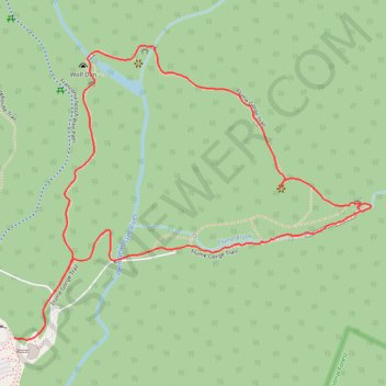
- Distance: 2.1 mi
- Elevation gain: 151 m
- Maximum elevation: 500 m
- Elevation loss: 151 m
- Minimum elevation: 389 m
- Moving time: 48 m 22 s
- Moving speed: 2.6 mph
- Maximum speed: 6.4 mph
- Total time: 54 m 54 s
- Global speed: 2.3 mph
Interactive trail map
Trail profile
- Distance: 2.1 mi
- Elevation gain: 151 m
- Maximum elevation: 500 m
- Elevation loss: 151 m
- Minimum elevation: 389 m
- Moving time: 48 m 22 s
- Moving speed: 2.6 mph
- Maximum speed: 6.4 mph
- Total time: 54 m 54 s
- Global speed: 2.3 mph
About this trail
Name: Flume Gorge Loop Trail in Franconia Notch State Park trail, distance, elevation, map, profile, GPS track
Start: Flume Gorge Trail, Lincoln, Grafton County, New Hampshire, United States (44.09742 -71.68055)
End: Flume Gorge Trail, Lincoln, Grafton County, New Hampshire, United States (44.09744 -71.67984)
Coordinates: 44.09737 -71.68055 44.10458 -71.66837
Other hiking, mountain biking, running and outdoor activity trails
Click on a trail to view its statistics, map and profile.