Import a GPX file

Mer Bleu Bog Trail

#Hiking #Loop

  • Distance: 0.9 mi
  • Elevation gain: 10 m
  • Maximum elevation: 75 m
  • Elevation loss: 10 m
  • Minimum elevation: 67 m

Interactive trail map

Trail profile

  • Distance: 0.9 mi
  • Elevation gain: 10 m
  • Maximum elevation: 75 m
  • Elevation loss: 10 m
  • Minimum elevation: 67 m

About this trail

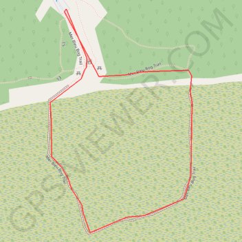
Name: Mer Bleu Bog Trail trail, distance, elevation, map, profile, GPS track

Start: P22, Ridge Road, Osgoode, Ottawa, Eastern Ontario, Ontario, K1W 0K7, Canada (45.39466 -75.51277)

End: P22, Ridge Road, Osgoode, Ottawa, Eastern Ontario, Ontario, K1W 0K7, Canada (45.39466 -75.51277)

Coordinates: 45.39006 -75.51324 45.39466 -75.50909

Other hiking, mountain biking, running and outdoor activity trails

Click on a trail to view its statistics, map and profile.

Québec - Montréal - Saint-Laurent River - Lake Ontario - Niagara Falls

Canada > Quebec > Urban agglomeration of Québec > Quebec

#Bike #Ontario

Distance: 670.1 mi • Elevation gain: 4,804 m • Maximum elevation: 209 m

Gear up for your next adventure:

🧷Tenacious Repair Tape - Instant fix for torn tents, jackets, or dry bags
📸Action Camera Chest Mounts - Record your ascent following topographic paths hands-free
🔥Reusable Hand Warmers - Maintain dexterity in your fingers for precise map handling
🧤Hiking Gloves - Warm and durable gloves for cold-weather walks
🕶️Glacier Goggles - Maximum protection for high-altitude snow topography

As an Amazon Associate, this site earns from qualifying purchases at no extra cost to you.