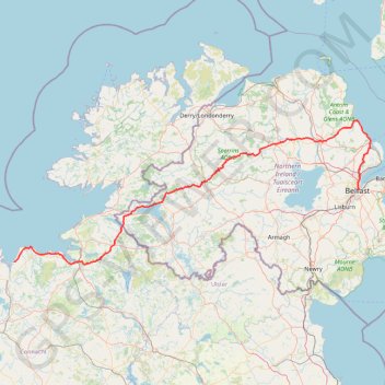
CTS-N.Irelandv1.1-Belfast-Titanic>Enniscrone-via antrim coast-209miles
- Distance: 208.7 mi
- Elevation gain: 3,985 m
- Maximum elevation: 271 m
- Elevation loss: 3,981 m
- Minimum elevation: 0 m
Interactive trail map
Trail profile
- Distance: 208.7 mi
- Elevation gain: 3,985 m
- Maximum elevation: 271 m
- Elevation loss: 3,981 m
- Minimum elevation: 0 m
About this trail
Name: CTS-N.Irelandv1.1-Belfast-Titanic>Enniscrone-via antrim coast-209miles trail, distance, elevation, map, profile, GPS track
Coordinates: 54.19749 -9.09619 54.97053 -5.80606
Topography: Belfast topographic map, elevation, terrain
Other hiking, mountain biking, running and outdoor activity trails
Click on a trail to view its statistics, map and profile.
Walk to the Doneens & top of Glencarr Waterfall
Glencarr Wood Walk
Distance: 5.5 mi • Elevation gain: 407 m • Maximum elevation: 424 m
Cnoc Ramhar
#Hiking #Loop #CnocRamhar #Atlantic
Distance: 7.2 mi • Elevation gain: 645 m • Maximum elevation: 568 m
Foyle Valley Cycle Route
United Kingdom > Northern Ireland > County Londonderry > Derry/Londonderry
Distance: 5.2 mi • Elevation gain: 63 m • Maximum elevation: 38 m
Walk to the summit of Benbulbin
Benbulban Head Walk
Distance: 6.8 mi • Elevation gain: 498 m • Maximum elevation: 521 m
Newry Canal Towpath
United Kingdom > Northern Ireland > County Armagh > Portadown
Distance: 20.1 mi • Elevation gain: 95 m • Maximum elevation: 29 m
Further traces in Brackmuckley Forest
United Kingdom > Northern Ireland > County Antrim > Portglenone
Distance: 1.8 mi • Elevation gain: 12 m • Maximum elevation: 22 m
Cycle up Divis and Black Mountain
United Kingdom > Northern Ireland > County Down > Belfast
Divis, Black Mountain, Cycle, Bicycle
Distance: 16.6 mi • Elevation gain: 426 m • Maximum elevation: 383 m
Forth Meadows Greenway, Belfast
United Kingdom > Northern Ireland > County Down > Belfast
Cycling
Distance: 15.8 mi • Elevation gain: 233 m • Maximum elevation: 78 m
Belfast to Dungannon
United Kingdom > Northern Ireland > County Antrim > Belfast
Bicycle ride from Belfast Big Fish to Dungannon.
Distance: 51.7 mi • Elevation gain: 549 m • Maximum elevation: 75 m
Scrabo Loop
United Kingdom > Northern Ireland > County Down > Belfast
Cycling belfast, newtownards, comber, dundonald, holywood, bicycle
Distance: 25.8 mi • Elevation gain: 401 m • Maximum elevation: 156 m
Lagan & Lough
United Kingdom > Northern Ireland > County Antrim > Tullynacross
Distance: 18.3 mi • Elevation gain: 153 m • Maximum elevation: 35 m
The Devils Chimney
Distance: 1.3 mi • Elevation gain: 114 m • Maximum elevation: 163 m
Forest path near Shimna River
United Kingdom > Northern Ireland > Bryansford
Distance: 0.4 mi • Elevation gain: 10 m • Maximum elevation: 45 m