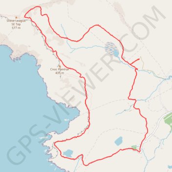
Cnoc Ramhar
#Hiking #Loop #CnocRamhar #Atlantic
- Distance: 7.2 mi
- Elevation gain: 645 m
- Maximum elevation: 568 m
- Elevation loss: 647 m
- Minimum elevation: 94 m
- Moving time: 3 h 14 m
- Moving speed: 2.2 mph
- Maximum speed: 4.9 mph
- Total time: 4 h 43 m
- Global speed: 1.5 mph
Interactive trail map
Trail profile
- Distance: 7.2 mi
- Elevation gain: 645 m
- Maximum elevation: 568 m
- Elevation loss: 647 m
- Minimum elevation: 94 m
- Moving time: 3 h 14 m
- Moving speed: 2.2 mph
- Maximum speed: 4.9 mph
- Total time: 4 h 43 m
- Global speed: 1.5 mph
About this trail
Name: Cnoc Ramhar trail, distance, elevation, map, profile, GPS track
Coordinates: 54.62390 -8.69345 54.65023 -8.65817
Other hiking, mountain biking, running and outdoor activity trails
Click on a trail to view its statistics, map and profile.
CTS-N.Irelandv1.1-Belfast-Titanic>Enniscrone-via antrim coast-209miles
United Kingdom > Northern Ireland > County Down > Belfast
Distance: 208.7 mi • Elevation gain: 3,985 m • Maximum elevation: 271 m