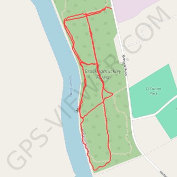
Further traces in Brackmuckley Forest
- Distance: 1.8 mi
- Elevation gain: 12 m
- Maximum elevation: 22 m
- Elevation loss: 13 m
- Minimum elevation: 17 m
- Moving time: 48 m 4 s
- Moving speed: 2.2 mph
- Maximum speed: 4.5 mph
- Total time: 49 m 18 s
- Global speed: 2.2 mph
Interactive trail map
Trail profile
- Distance: 1.8 mi
- Elevation gain: 12 m
- Maximum elevation: 22 m
- Elevation loss: 13 m
- Minimum elevation: 17 m
- Moving time: 48 m 4 s
- Moving speed: 2.2 mph
- Maximum speed: 4.5 mph
- Total time: 49 m 18 s
- Global speed: 2.2 mph
About this trail
Name: Further traces in Brackmuckley Forest trail, distance, elevation, map, profile, GPS track
Coordinates: 54.87964 -6.48844 54.88563 -6.48533
Topography: County Antrim topographic map, elevation, terrain
Other hiking, mountain biking, running and outdoor activity trails
Click on a trail to view its statistics, map and profile.
CTS-N.Irelandv1.1-Belfast-Titanic>Enniscrone-via antrim coast-209miles
United Kingdom > Northern Ireland > County Down > Belfast
Distance: 208.7 mi • Elevation gain: 3,985 m • Maximum elevation: 271 m