
Scrabo Loop
Cycling
belfast, newtownards, comber, dundonald, holywood, bicycle
- Distance: 25.8 mi
- Elevation gain: 401 m
- Maximum elevation: 156 m
- Elevation loss: 401 m
- Minimum elevation: 0 m
- Moving time: 2 h 13 m
- Moving speed: 11.6 mph
- Maximum speed: 26.4 mph
- Total time: 2 h 51 m
- Global speed: 9.0 mph
Interactive trail map
Trail profile
- Distance: 25.8 mi
- Elevation gain: 401 m
- Maximum elevation: 156 m
- Elevation loss: 401 m
- Minimum elevation: 0 m
- Moving time: 2 h 13 m
- Moving speed: 11.6 mph
- Maximum speed: 26.4 mph
- Total time: 2 h 51 m
- Global speed: 9.0 mph
About this trail
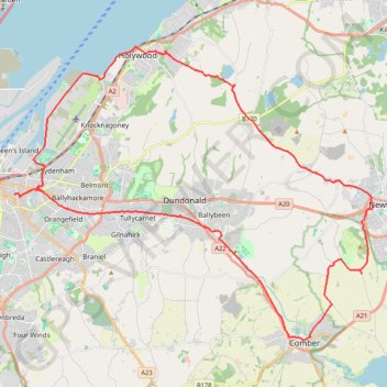
Name: Scrabo Loop trail, distance, elevation, map, profile, GPS track
Coordinates: 54.55050 -5.90293 54.64290 -5.70810
Topography: Belfast topographic map, elevation, terrain
Other hiking, mountain biking, running and outdoor activity trails
Click on a trail to view its statistics, map and profile.

CTS-N.Irelandv1.1-Belfast-Titanic>Enniscrone-via antrim coast-209miles
United Kingdom > Northern Ireland > County Down > Belfast
Distance: 208.7 mi • Elevation gain: 3,985 m • Maximum elevation: 271 m

Cycle up Divis and Black Mountain
United Kingdom > Northern Ireland > County Down > Belfast
Divis, Black Mountain, Cycle, Bicycle
Distance: 16.6 mi • Elevation gain: 426 m • Maximum elevation: 383 m

Forth Meadows Greenway, Belfast
United Kingdom > Northern Ireland > County Down > Belfast
Cycling
Distance: 15.8 mi • Elevation gain: 233 m • Maximum elevation: 78 m

Lagan & Lough
United Kingdom > Northern Ireland > County Antrim > Tullynacross
Distance: 18.3 mi • Elevation gain: 153 m • Maximum elevation: 35 m