Mid wales again
- Distance: 126.6 mi
- Elevation gain: 4,902 m
- Maximum elevation: 545 m
- Elevation loss: 4,901 m
- Minimum elevation: 94 m
- Moving time: 6 h 36 s
- Moving speed: 21.1 mph
- Maximum speed: 49.5 mph
- Total time: 8 h 56 m
- Global speed: 14.2 mph
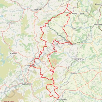
Interactive trail map
Trail profile
- Distance: 126.6 mi
- Elevation gain: 4,902 m
- Maximum elevation: 545 m
- Elevation loss: 4,901 m
- Minimum elevation: 94 m
- Moving time: 6 h 36 s
- Moving speed: 21.1 mph
- Maximum speed: 49.5 mph
- Total time: 8 h 56 m
- Global speed: 14.2 mph
About this trail
Name: Mid wales again trail, distance, elevation, map, profile, GPS track
Start: Freerein Riding Holidays, A438, Clyro, Powys, Wales, HR3 5LE, United Kingdom (52.07946 -3.15511)
End: Freerein Riding Holidays, A438, Clyro, Powys, Wales, HR3 5LE, United Kingdom (52.07942 -3.15531)
Coordinates: 52.07911 -3.38037 52.53990 -3.04289
Topography: Powys topographic map, elevation, terrain
Other hiking, mountain biking, running and outdoor activity trails
Click on a trail to view its statistics, map and profile.
The Headstock 500
United Kingdom > Wales > Newport > Newport
Distance: 300.4 mi • Elevation gain: 9,616 m • Maximum elevation: 691 m
Bishops Castle to Clun
United Kingdom > England > Shropshire > Bishop's Castle
Distance: 12.9 mi • Elevation gain: 606 m • Maximum elevation: 403 m
Knighton circular walk on public foot paths
United Kingdom > Wales > Powys > Knighton
Distance: 9.1 mi • Elevation gain: 396 m • Maximum elevation: 413 m
Hergest Ridge and Hergest Croft Gardens
United Kingdom > England > Herefordshire > Kington
Distance: 7.7 mi • Elevation gain: 351 m • Maximum elevation: 415 m
Cusop Hill
United Kingdom > England > Herefordshire > Cusop
Distance: 9.4 mi • Elevation gain: 388 m • Maximum elevation: 394 m
Clyro
United Kingdom > England > Herefordshire > Cusop
Distance: 7.9 mi • Elevation gain: 289 m • Maximum elevation: 229 m