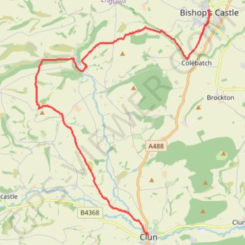
Bishops Castle to Clun
- Distance: 12.9 mi
- Elevation gain: 606 m
- Maximum elevation: 403 m
- Elevation loss: 614 m
- Minimum elevation: 179 m
- Moving time: 5 h 49 m
- Moving speed: 2.2 mph
- Maximum speed: 3.8 mph
- Total time: 6 h 58 m
- Global speed: 1.8 mph
Interactive trail map
Trail profile
- Distance: 12.9 mi
- Elevation gain: 606 m
- Maximum elevation: 403 m
- Elevation loss: 614 m
- Minimum elevation: 179 m
- Moving time: 5 h 49 m
- Moving speed: 2.2 mph
- Maximum speed: 3.8 mph
- Total time: 6 h 58 m
- Global speed: 1.8 mph
About this trail
Name: Bishops Castle to Clun trail, distance, elevation, map, profile, GPS track
End: The White Horse, The Square, Clun, Shropshire, England, SY7 8JP, United Kingdom (52.42144 -3.03018)
Coordinates: 52.42144 -3.09005 52.49452 -2.99774
Topography: Shropshire topographic map, elevation, terrain
Other hiking, mountain biking, running and outdoor activity trails
Click on a trail to view its statistics, map and profile.
Clun to Craven Arms
United Kingdom > England > Shropshire > Clun
Distance: 11.8 mi • Elevation gain: 490 m • Maximum elevation: 391 m
Mid wales again
United Kingdom > Wales > Powys > Clyro
Distance: 126.6 mi • Elevation gain: 4,902 m • Maximum elevation: 545 m