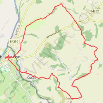
Cusop Hill
- Distance: 9.4 mi
- Elevation gain: 388 m
- Maximum elevation: 394 m
- Elevation loss: 387 m
- Minimum elevation: 84 m
- Moving time: 4 h 55 m
- Moving speed: 1.9 mph
- Maximum speed: 4.2 mph
- Total time: 6 h 50 m
- Global speed: 1.4 mph
Interactive trail map
Trail profile
- Distance: 9.4 mi
- Elevation gain: 388 m
- Maximum elevation: 394 m
- Elevation loss: 387 m
- Minimum elevation: 84 m
- Moving time: 4 h 55 m
- Moving speed: 1.9 mph
- Maximum speed: 4.2 mph
- Total time: 6 h 50 m
- Global speed: 1.4 mph
About this trail
Name: Cusop Hill trail, distance, elevation, map, profile, GPS track
Start: Thirty Acres, Cusop, Herefordshire, England, HR3 5RF, United Kingdom (52.06835 -3.11443)
End: Thirty Acres, Cusop, Herefordshire, England, HR3 5RF, United Kingdom (52.06871 -3.11404)
Coordinates: 52.05849 -3.12731 52.09417 -3.07056
Topography: Herefordshire topographic map, elevation, terrain
Other hiking, mountain biking, running and outdoor activity trails
Click on a trail to view its statistics, map and profile.
The Headstock 500
United Kingdom > Wales > Newport > Newport
Distance: 300.4 mi • Elevation gain: 9,616 m • Maximum elevation: 691 m
Mid wales again
United Kingdom > Wales > Powys > Clyro
Distance: 126.6 mi • Elevation gain: 4,902 m • Maximum elevation: 545 m
Clyro
United Kingdom > England > Herefordshire > Cusop
Distance: 7.9 mi • Elevation gain: 289 m • Maximum elevation: 229 m