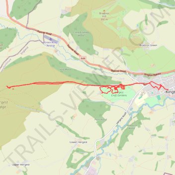
Hergest Ridge and Hergest Croft Gardens
- Distance: 7.7 mi
- Elevation gain: 351 m
- Maximum elevation: 415 m
- Elevation loss: 354 m
- Minimum elevation: 161 m
- Moving time: 4 h 5 m
- Moving speed: 1.9 mph
- Maximum speed: 9.5 mph
- Total time: 6 h 4 m
- Global speed: 1.3 mph
Interactive trail map
Trail profile
- Distance: 7.7 mi
- Elevation gain: 351 m
- Maximum elevation: 415 m
- Elevation loss: 354 m
- Minimum elevation: 161 m
- Moving time: 4 h 5 m
- Moving speed: 1.9 mph
- Maximum speed: 9.5 mph
- Total time: 6 h 4 m
- Global speed: 1.3 mph
About this trail
Name: Hergest Ridge and Hergest Croft Gardens trail, distance, elevation, map, profile, GPS track
Coordinates: 52.20252 -3.08464 52.20496 -3.03030
Topography: Herefordshire topographic map, elevation, terrain
Other hiking, mountain biking, running and outdoor activity trails
Click on a trail to view its statistics, map and profile.
The Headstock 500
United Kingdom > Wales > Newport > Newport
Distance: 300.4 mi • Elevation gain: 9,616 m • Maximum elevation: 691 m
Mid wales again
United Kingdom > Wales > Powys > Clyro
Distance: 126.6 mi • Elevation gain: 4,902 m • Maximum elevation: 545 m