Make a donation
Gear up for your next adventure:
As an Amazon Associate, this site earns from qualifying purchases at no extra cost to you.
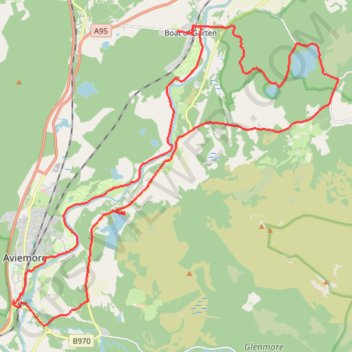
Aviemore to Loch Garten: A Tale of Trails and Trials
- Distance: 22.0 mi
- Elevation gain: 261 m
- Maximum elevation: 244 m
- Elevation loss: 261 m
- Minimum elevation: 202 m
- Moving time: 3 h 29 m
- Moving speed: 6.3 mph
- Maximum speed: 21.1 mph
- Total time: 4 h 27 m
- Global speed: 4.9 mph
Interactive trail map
Make a donation
Gear up for your next adventure:
As an Amazon Associate, this site earns from qualifying purchases at no extra cost to you.
Trail profile
- Distance: 22.0 mi
- Elevation gain: 261 m
- Maximum elevation: 244 m
- Elevation loss: 261 m
- Minimum elevation: 202 m
- Moving time: 3 h 29 m
- Moving speed: 6.3 mph
- Maximum speed: 21.1 mph
- Total time: 4 h 27 m
- Global speed: 4.9 mph
Make a donation
Gear up for your next adventure:
As an Amazon Associate, this site earns from qualifying purchases at no extra cost to you.
About this trail
Name: Aviemore to Loch Garten: A Tale of Trails and Trials trail, distance, elevation, map, profile, GPS track
End: B9152, Aviemore, Highland, Scotland, PH22 1PT, United Kingdom (57.18319 -3.83326)
Coordinates: 57.17698 -3.83385 57.25063 -3.68692
Topography: Highland topographic map, elevation, terrain
Make a donation
Gear up for your next adventure:
As an Amazon Associate, this site earns from qualifying purchases at no extra cost to you.
Other hiking, mountain biking, running and outdoor activity trails
Click on a trail to view its statistics, map and profile.
Cairngorms hike
United Kingdom > Scotland > Highland > Aviemore
Distance: 50.2 mi • Elevation gain: 3,001 m • Maximum elevation: 1,312 m
Glenmore - Meall a' Bhuachaille - Ryvoan Bothy
United Kingdom > Scotland > Highland > Glenmore
Distance: 5.5 mi • Elevation gain: 564 m • Maximum elevation: 807 m
Tracks in Docharn forest and surrounding
United Kingdom > Scotland > Highland > Grantown-on-Spey
Highlands Gravel/Unpaved Cycling
Distance: 28.2 mi • Elevation gain: 572 m • Maximum elevation: 339 m
Make a donation
Gear up for your next adventure:
As an Amazon Associate, this site earns from qualifying purchases at no extra cost to you.
Hike up Craigellachie from Aviemore
United Kingdom > Scotland > Highland > Aviemore
Distance: 3.8 mi • Elevation gain: 287 m • Maximum elevation: 492 m