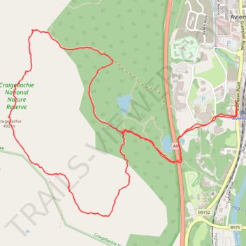
Hike up Craigellachie from Aviemore
- Distance: 3.8 mi
- Elevation gain: 287 m
- Maximum elevation: 492 m
- Elevation loss: 286 m
- Minimum elevation: 214 m
- Moving time: 2 h 1 s
- Moving speed: 1.9 mph
- Maximum speed: 10.3 mph
- Total time: 2 h 43 m
- Global speed: 1.4 mph
Interactive trail map
Trail profile
- Distance: 3.8 mi
- Elevation gain: 287 m
- Maximum elevation: 492 m
- Elevation loss: 286 m
- Minimum elevation: 214 m
- Moving time: 2 h 1 s
- Moving speed: 1.9 mph
- Maximum speed: 10.3 mph
- Total time: 2 h 43 m
- Global speed: 1.4 mph
About this trail
Name: Hike up Craigellachie from Aviemore trail, distance, elevation, map, profile, GPS track
Coordinates: 57.18234 -3.85350 57.19301 -3.82946
Topography: Highland topographic map, elevation, terrain
Other hiking, mountain biking, running and outdoor activity trails
Click on a trail to view its statistics, map and profile.
Cairngorms hike
United Kingdom > Scotland > Highland > Aviemore
Distance: 50.2 mi • Elevation gain: 3,001 m • Maximum elevation: 1,312 m
Aviemore to Loch Garten: A Tale of Trails and Trials
United Kingdom > Scotland > Highland > Aviemore
Distance: 22.0 mi • Elevation gain: 261 m • Maximum elevation: 244 m