Tracks in Docharn forest and surrounding
Highlands Gravel/Unpaved Cycling
- Distance: 28.2 mi
- Elevation gain: 572 m
- Maximum elevation: 339 m
- Elevation loss: 570 m
- Minimum elevation: 193 m
- Moving time: 3 h 2 m
- Moving speed: 9.3 mph
- Maximum speed: 30.2 mph
- Total time: 4 h 8 m
- Global speed: 6.8 mph
Interactive trail map
Trail profile
- Distance: 28.2 mi
- Elevation gain: 572 m
- Maximum elevation: 339 m
- Elevation loss: 570 m
- Minimum elevation: 193 m
- Moving time: 3 h 2 m
- Moving speed: 9.3 mph
- Maximum speed: 30.2 mph
- Total time: 4 h 8 m
- Global speed: 6.8 mph
About this trail
Name: Tracks in Docharn forest and surrounding trail, distance, elevation, map, profile, GPS track
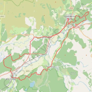
Start: Woodburn Drive, Grantown-on-Spey, Highland, Scotland, PH26 3FD, United Kingdom (57.32745 -3.61637)
End: Woodburn Drive, Grantown-on-Spey, Highland, Scotland, PH26 3FD, United Kingdom (57.32674 -3.61687)
Coordinates: 57.24683 -3.77228 57.33709 -3.56540
Topography: Highland topographic map, elevation, terrain
Other hiking, mountain biking, running and outdoor activity trails
Click on a trail to view its statistics, map and profile.
Aviemore to Loch Garten: A Tale of Trails and Trials
United Kingdom > Scotland > Highland > Aviemore
Distance: 22.0 mi • Elevation gain: 261 m • Maximum elevation: 244 m
Docharn wood track
United Kingdom > Scotland > Highland > Dulnain Bridge > Chapleton
Docharn track only
Distance: 3.1 mi • Elevation gain: 138 m • Maximum elevation: 339 m