Make a donation
Gear up for your next adventure:
As an Amazon Associate, this site earns from qualifying purchases at no extra cost to you.
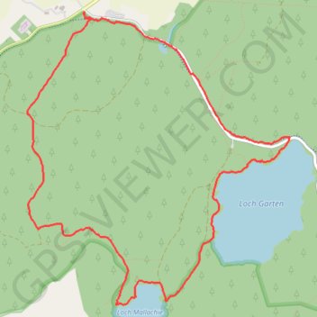
Forest walk along Loch Garten and Loch Mallachie
Interactive trail map
Make a donation
Gear up for your next adventure:
As an Amazon Associate, this site earns from qualifying purchases at no extra cost to you.
Trail profile
- Distance: 4.8 mi
- Elevation gain: 81 m
- Maximum elevation: 244 m
- Elevation loss: 80 m
- Minimum elevation: 209 m
- Moving time: 2 h 5 m
- Moving speed: 2.3 mph
- Maximum speed: 4.5 mph
- Total time: 2 h 9 m
- Global speed: 2.2 mph
Make a donation
Gear up for your next adventure:
As an Amazon Associate, this site earns from qualifying purchases at no extra cost to you.
About this trail
Name: Forest walk along Loch Garten and Loch Mallachie trail, distance, elevation, map, profile, GPS track
Start: Highland, Scotland, PH24 3BY, United Kingdom (57.25456 -3.72449)
End: Highland, Scotland, PH24 3BY, United Kingdom (57.25449 -3.72446)
Coordinates: 57.23492 -3.73156 57.25456 -3.69906
Topography: Highland topographic map, elevation, terrain
Make a donation
Gear up for your next adventure:
As an Amazon Associate, this site earns from qualifying purchases at no extra cost to you.
Other hiking, mountain biking, running and outdoor activity trails
Click on a trail to view its statistics, map and profile.
Aviemore to Loch Garten: A Tale of Trails and Trials
United Kingdom > Scotland > Highland > Aviemore
Distance: 22.0 mi • Elevation gain: 261 m • Maximum elevation: 244 m
Tracks in Docharn forest and surrounding
United Kingdom > Scotland > Highland > Grantown-on-Spey
Highlands Gravel/Unpaved Cycling
Distance: 28.2 mi • Elevation gain: 572 m • Maximum elevation: 339 m