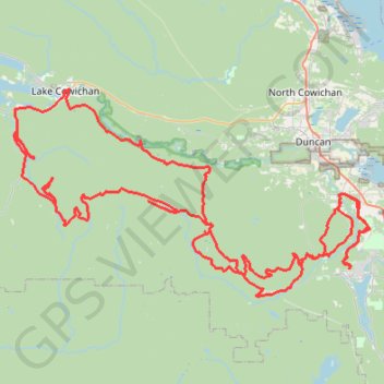
Robertson River Falls dual sport ride (not BBF)
Full day dual sport loop, from Shawnigan to Robertson River Falls and back. Not BBF due to gates and Hillclimb.
- Distance: 127.2 mi
- Elevation gain: 5,260 m
- Maximum elevation: 785 m
- Elevation loss: 5,260 m
- Minimum elevation: 14 m
- Moving time: 6 h 3 m
- Moving speed: 21.0 mph
- Maximum speed: 50.5 mph
- Total time: 8 h 24 m
- Global speed: 15.1 mph
Interactive trail map
Trail profile
- Distance: 127.2 mi
- Elevation gain: 5,260 m
- Maximum elevation: 785 m
- Elevation loss: 5,260 m
- Minimum elevation: 14 m
- Moving time: 6 h 3 m
- Moving speed: 21.0 mph
- Maximum speed: 50.5 mph
- Total time: 8 h 24 m
- Global speed: 15.1 mph
About this trail
Name: Robertson River Falls dual sport ride (not BBF) trail, distance, elevation, map, profile, GPS track
Coordinates: 48.63435 -124.12815 48.82868 -123.62893
Other hiking, mountain biking, running and outdoor activity trails
Click on a trail to view its statistics, map and profile.
Cobble Hill Loop
Canada > British Columbia > Cowichan Valley Regional District > Area C (Cobble Hill) > Cobble Hill
Cobble Hill Mountain Regional Recreation Area. #Hiking #MTB #Loop #CobbleHill
Distance: 4.5 mi • Elevation gain: 325 m • Maximum elevation: 320 m
Mount Prevost
Canada > British Columbia > Cowichan Valley Regional District > North Cowichan
North Cowichan Municipal Forest Reserve. Vancouver Island. #Hiking #Loop #NorthCowichan #Vancouver
Distance: 6.7 mi • Elevation gain: 702 m • Maximum elevation: 748 m
BBF loop to the Skydeck in Nanaimo
Canada > British Columbia > Cowichan Valley Regional District > Area A (Mill Bay / Malahat) > Mill Bay
BBF loop to the Skydeck
Distance: 201.0 mi • Elevation gain: 6,222 m • Maximum elevation: 706 m