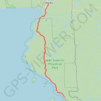
Wawa - Lake Superior Provincial Park
#Bike #Wawa #LakeSuperior
- Distance: 55.5 mi
- Elevation gain: 890 m
- Maximum elevation: 408 m
- Elevation loss: 994 m
- Minimum elevation: 185 m
Interactive trail map
Trail profile
- Distance: 55.5 mi
- Elevation gain: 890 m
- Maximum elevation: 408 m
- Elevation loss: 994 m
- Minimum elevation: 185 m
About this trail
Name: Wawa - Lake Superior Provincial Park trail, distance, elevation, map, profile, GPS track
Coordinates: 47.33128 -84.90154 47.98533 -84.61317
Other hiking, mountain biking, running and outdoor activity trails
Click on a trail to view its statistics, map and profile.
Lake Superior Provincial Park - Harmony Beach
Canada > Ontario > Algoma District > Unorganized North Algoma
Distance: 58.5 mi • Elevation gain: 917 m • Maximum elevation: 387 m
White River - Wawa
Canada > Ontario > Algoma District > White River Township
#Bike #WhiteRiver #Wawa
Distance: 57.3 mi • Elevation gain: 560 m • Maximum elevation: 471 m
Ride from Sandy Beach
Canada > Ontario > Algoma District > Wawa
Distance: 4.5 mi • Elevation gain: 139 m • Maximum elevation: 247 m