Thank you for supporting this site ❤️
Make a donation
Make a donation
Gear up for your next adventure:
As an Amazon Associate, this site earns from qualifying purchases at no extra cost to you.
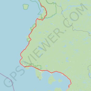
Lake Superior Provincial Park - Harmony Beach
- Distance: 58.5 mi
- Elevation gain: 917 m
- Maximum elevation: 387 m
- Elevation loss: 920 m
- Minimum elevation: 180 m
Interactive trail map
Thank you for supporting this site ❤️
Make a donation
Make a donation
Gear up for your next adventure:
As an Amazon Associate, this site earns from qualifying purchases at no extra cost to you.
Trail profile
- Distance: 58.5 mi
- Elevation gain: 917 m
- Maximum elevation: 387 m
- Elevation loss: 920 m
- Minimum elevation: 180 m
Thank you for supporting this site ❤️
Make a donation
Make a donation
Gear up for your next adventure:
As an Amazon Associate, this site earns from qualifying purchases at no extra cost to you.
About this trail
Name: Lake Superior Provincial Park - Harmony Beach trail, distance, elevation, map, profile, GPS track
Coordinates: 46.84601 -84.78755 47.33142 -84.35312
Thank you for supporting this site ❤️
Make a donation
Make a donation
Gear up for your next adventure:
As an Amazon Associate, this site earns from qualifying purchases at no extra cost to you.
Other hiking, mountain biking, running and outdoor activity trails
Click on a trail to view its statistics, map and profile.
Wawa - Lake Superior Provincial Park
Canada > Ontario > Algoma District > Wawa
#Bike #Wawa #LakeSuperior
Distance: 55.5 mi • Elevation gain: 890 m • Maximum elevation: 408 m