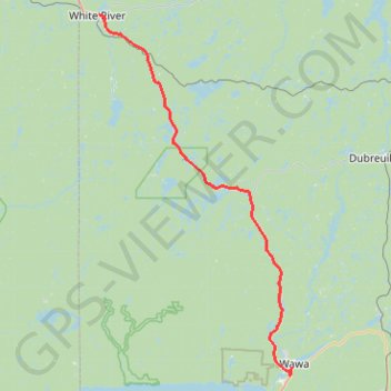
White River - Wawa
#Bike #WhiteRiver #Wawa
- Distance: 57.3 mi
- Elevation gain: 560 m
- Maximum elevation: 471 m
- Elevation loss: 645 m
- Minimum elevation: 253 m
Interactive trail map
Trail profile
- Distance: 57.3 mi
- Elevation gain: 560 m
- Maximum elevation: 471 m
- Elevation loss: 645 m
- Minimum elevation: 253 m
About this trail
Name: White River - Wawa trail, distance, elevation, map, profile, GPS track
Coordinates: 47.97074 -85.27875 48.59450 -84.78024
Other hiking, mountain biking, running and outdoor activity trails
Click on a trail to view its statistics, map and profile.
Wawa - Lake Superior Provincial Park
Canada > Ontario > Algoma District > Wawa
#Bike #Wawa #LakeSuperior
Distance: 55.5 mi • Elevation gain: 890 m • Maximum elevation: 408 m
Riding to Magpie Mine
Canada > Ontario > Algoma District > Unorganized North Algoma
Distance: 8.6 mi • Elevation gain: 124 m • Maximum elevation: 441 m