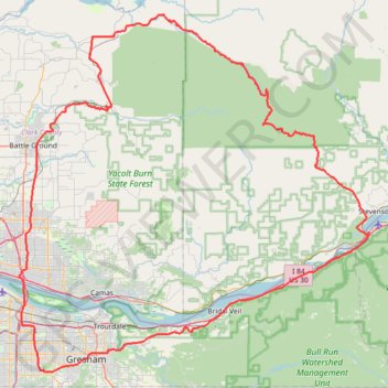
Expedition to Sedum Ridge
- Distance: 133.4 mi
- Elevation gain: 5,093 m
- Maximum elevation: 1,169 m
- Elevation loss: 5,092 m
- Minimum elevation: 4 m
- Moving time: 10 h 45 m
- Moving speed: 12.4 mph
- Maximum speed: 41.0 mph
- Total time: 12 h 26 m
- Global speed: 10.7 mph
Interactive trail map
Trail profile
- Distance: 133.4 mi
- Elevation gain: 5,093 m
- Maximum elevation: 1,169 m
- Elevation loss: 5,092 m
- Minimum elevation: 4 m
- Moving time: 10 h 45 m
- Moving speed: 12.4 mph
- Maximum speed: 41.0 mph
- Total time: 12 h 26 m
- Global speed: 10.7 mph
About this trail
Name: Expedition to Sedum Ridge trail, distance, elevation, map, profile, GPS track
Coordinates: 45.47844 -122.56136 45.95353 -121.89527
Other hiking, mountain biking, running and outdoor activity trails
Click on a trail to view its statistics, map and profile.
Multnomah Falls via Larch Mountain Trail in Columbia River Gorge National Scenic Area
United States > Oregon > Multnomah County
The hike from Larch Mountain Trail to Multnomah Falls offers a captivating journey through lush forests, characterized by vibrant wildflowers and stunning views of cascading waterfalls. As you ascend, you'll encounter picturesque vistas, including glimpses of the Columbia River Gorge. The trail provides a…
Distance: 2.3 mi • Elevation gain: 441 m • Maximum elevation: 254 m
Wahclella Falls Trail in Columbia River Gorge National Scenic Area
United States > Oregon > Multnomah County > Bonneville
The Wahclella Falls Trail offers hikers a serene journey through the lush Columbia River Gorge. Along the path, you'll encounter the cascading Munra Falls, dense moss-covered forests, and the majestic two-tiered Wahclella Falls, which plunges into a tranquil pool surrounded by basalt cliffs. This picturesque…
Distance: 1.9 mi • Elevation gain: 246 m • Maximum elevation: 151 m
Multnomah Falls, Ecola Falls and Wahkeena Falls Loop
United States > Oregon > Multnomah County
Loop hike via Larch Mountain Trail, Benson Bridge, Lower Multnomah Falls, Dutchman Falls, Wiesendanger Falls, Ecola Falls, Wahkeena Trail, Fairy Falls, Lemmons Viewpoint, Wahkeena Falls and Return Trail in the Mount Hood National Forest above the Benson Lake and the Columbia River. #Hiking #Loop #Falls #River…
Distance: 5.7 mi • Elevation gain: 1,042 m • Maximum elevation: 506 m
Wahclella Falls Trail in Columbia River Gorge National Scenic Area
United States > Oregon > Multnomah County > Bonneville
The Wahclella Falls Trail offers a serene, moderately challenging hike through a lush canyon. As you follow Tanner Creek, you'll pass smaller waterfalls like Munra Falls before arriving at the two-tiered Wahclella Falls, which cascades into a pool below. The trail is well-maintained, but some sections are…
Distance: 2.2 mi • Elevation gain: 330 m • Maximum elevation: 148 m
Cape Horn Loop Trail in Columbia River Gorge National Scenic Area
United States > Washington > Skamania County
The Cape Horn Loop Trail offers hikers a blend of forested paths, panoramic viewpoints, and intriguing geological formations, making it a fantastic hike in the Columbia River Gorge. Along the route, visitors can enjoy sweeping views of the Columbia River, including distant landmarks like Beacon Rock and…
Distance: 7.0 mi • Elevation gain: 634 m • Maximum elevation: 388 m
Tunnel Falls via Eagle Creek Trail in Columbia River Gorge National Scenic Area
United States > Oregon > Hood River County
The Eagle Creek Trail to Tunnel Falls offers hikers a captivating journey through the Columbia River Gorge, showcasing a series of stunning waterfalls, including the iconic Tunnel Falls, where the trail passes behind a 172-foot cascade. Along the way, hikers encounter diverse landscapes, from lush forests to…
Distance: 12.1 mi • Elevation gain: 1,057 m • Maximum elevation: 407 m
Punchbowl Falls via Eagle Creek in Columbia River Gorge National Scenic Area
United States > Oregon > Multnomah County
The Eagle Creek Trail to Punchbowl Falls offers hikers a journey through lush old-growth forests, with the trail meandering alongside the clear waters of Eagle Creek. Along the way, you'll encounter several cascading waterfalls, including the impressive Punchbowl Falls, where water plunges into a large,…
Distance: 5.1 mi • Elevation gain: 543 m • Maximum elevation: 193 m
Punchbowl Falls via Eagle Creek Trail in Columbia River Gorge National Scenic Area
United States > Oregon > Multnomah County
The hike to Punchbowl Falls via the Eagle Creek Trail offers a beautiful and immersive experience among lush forests and dramatic landscapes. Along the route, hikers can enjoy breathtaking views of cascading waterfalls, such as Metlako Falls and Twister Falls, while navigating sections of the trail that follow…
Distance: 5.6 mi • Elevation gain: 615 m • Maximum elevation: 195 m
Wahkeena Trail and Larch Mountain Trail Loop via Wahkeena Falls and Multnomah Falls in Columbia River Gorge National Scenic Area
United States > Oregon > Multnomah County
The Wahkeena Trail and Larch Mountain Trail Loop offers a captivating hiking experience through the lush landscapes of the Columbia River Gorge. Hikers will encounter stunning vistas, including the iconic Multnomah Falls and the serene Wahkeena Falls, alongside charming features like Fairy Falls and…
Distance: 5.5 mi • Elevation gain: 812 m • Maximum elevation: 508 m
Cape Horn Viewpoint Loop via Cape Horn Trail, Cape Horn Falls, Windblown Fir Viewpoint and Pioneer Point
United States > Washington > Skamania County
The Cape Horn Viewpoint Loop in Gifford Pinchot National Forest offers an immersive hiking experience with a variety of stunning landscapes. As you hike, you'll enjoy panoramic views of the Columbia River Gorge, including nearby peaks like Hamilton Mountain. The trail also passes the scenic Cape Horn Falls and…
Distance: 6.5 mi • Elevation gain: 569 m • Maximum elevation: 388 m
Hamilton Mountain Loop Trail via Little Hamilton Mountain and Hamilton Saddle
United States > Washington > Skamania County
The Hamilton Mountain Loop Trail in Beacon Rock State Park offers a dynamic hiking experience with varied landscapes. Hikers can expect to pass through lush forests, with an abundance of wildflowers in spring and colorful leaves in fall, before reaching impressive views of the Columbia River Gorge and…
Distance: 7.0 mi • Elevation gain: 741 m • Maximum elevation: 705 m
Hamilton Mountain Loop Trail via Hardy Falls, Rodney Falls and Hardy Creek
United States > Washington > Skamania County
The Hamilton Mountain Loop Trail in Beacon Rock State Park offers a rewarding experience for hikers seeking both natural beauty and a physical challenge. Along the way, hikers will encounter cascading waterfalls like Hardy Falls and Rodney Falls, each framed by lush greenery. The trail also provides panoramic…
Distance: 7.4 mi • Elevation gain: 790 m • Maximum elevation: 705 m
Angel's Rest Trail in Columbia River Gorge National Scenic Area
United States > Oregon > Multnomah County > Bridal Veil
The Angel’s Rest Trail offers a rewarding hike with sweeping views of the Columbia River, surrounding mountains, and lush forests. As you ascend, the trail passes through forested sections with occasional stream crossings before opening up to vistas, especially after the landscape thinned from past…
Distance: 4.4 mi • Elevation gain: 487 m • Maximum elevation: 477 m
Latourell Falls Loop Trail in Guy W. Talbot State Park
United States > Oregon > Multnomah County > Latourell
The Latourell Falls Loop Trail offers a picturesque and relatively moderate hike through the lush forests of the Columbia River Gorge. Starting near the impressive Lower Latourell Falls, the trail quickly immerses you in a verdant landscape filled with moss-covered trees and ferns. As you ascend, you'll…
Distance: 2.2 mi • Elevation gain: 284 m • Maximum elevation: 240 m
Angel's Rest Trail in Mount Hood National Forest
United States > Oregon > Multnomah County > Corbett > Bridal Veil
The Angel's Rest Trail offers a beautiful hike with breathtaking views of the Columbia River Gorge. Starting through a lush forest, hikers will cross small streams and pass scenic waterfalls, including a view of Coopey Falls. As the trail ascends, the forest gives way to more open terrain, where you'll enjoy…
Distance: 4.6 mi • Elevation gain: 521 m • Maximum elevation: 476 m
Northern part of the Pacific Crest Trail (PCT)
United States > Oregon > Klamath County
Hike on the Pacific Crest National Scenic Trail from Crater Lake to Canada Border through Oregon and Washington along the Sierra Nevada and Cascade mountain ranges. #Hiking #Mountain #SierraNevada #Cascade #Nature #Forest #Park #PCT
Distance: 744.6 mi • Elevation gain: 44,308 m • Maximum elevation: 2,307 m
Eagle Creek and Falls
United States > Oregon > Hood River County
Hike from Columbia River to the Wahtum Lake along Eagle Creek via Metlako Falls, Sorenson Falls, Punch Bowl Falls, Four Mile Falls, Wy east Falls, Grand Union Falls, Tunnel Falls and Twister Falls in the Mark O. Hatfield Wilderness. #Hiking #River #Falls #Canyon #Forest #Mountain #Lake #Wilderness
Distance: 13.1 mi • Elevation gain: 1,778 m • Maximum elevation: 1,144 m
Lacamas Regional Park loop walk via Round Lake and Woodburn Park
United States > Washington > Clark County > Camas
Distance: 4.2 mi • Elevation gain: 138 m • Maximum elevation: 126 m
Portland Cyclocross - Happy Valley trails
United States > Oregon > Multnomah County > Portland
Distance: 13.1 mi • Elevation gain: 549 m • Maximum elevation: 321 m
Portland Gravel/Unpaved Cycling
United States > Oregon > Multnomah County > Portland
Distance: 31.0 mi • Elevation gain: 560 m • Maximum elevation: 145 m
Backpacked Tarbell Loop Trail
United States > Washington > Clark County
Distance: 28.5 mi • Elevation gain: 1,760 m • Maximum elevation: 1,010 m
The Watcher in the Water
United States > Oregon > Multnomah County > Portland
Distance: 51.5 mi • Elevation gain: 1,451 m • Maximum elevation: 300 m
Lake Oswego trails
United States > Oregon > Multnomah County > Portland
Happy Hour Lake Oswego
Distance: 43.2 mi • Elevation gain: 1,173 m • Maximum elevation: 222 m
Bridal Veil Falls Trail
United States > Oregon > Multnomah County
Distance: 0.7 mi • Elevation gain: 94 m • Maximum elevation: 84 m