Angel's Rest Trail in Mount Hood National Forest
The Angel's Rest Trail offers a beautiful hike with breathtaking views of the Columbia River Gorge. Starting through a lush forest, hikers will cross small streams and pass scenic waterfalls, including a view of Coopey Falls. As the trail ascends, the forest gives way to more open terrain, where you'll enjoy expansive vistas of Larch Mountain and the surrounding peaks, with the final viewpoint providing spectacular panoramic views that stretch to Portland and beyond. While the trail has areas with loose rocks and steep switchbacks, the rewarding summit views make it a popular and memorable hike. #Hiking #Forest #Nature #Waterfall #River
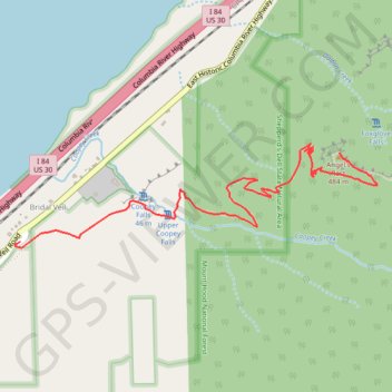
- Distance: 4.6 mi
- Elevation gain: 521 m
- Maximum elevation: 476 m
- Elevation loss: 524 m
- Minimum elevation: 50 m
Interactive trail map
Trail profile
- Distance: 4.6 mi
- Elevation gain: 521 m
- Maximum elevation: 476 m
- Elevation loss: 524 m
- Minimum elevation: 50 m
About this trail
Name: Angel's Rest Trail in Mount Hood National Forest trail, distance, elevation, map, profile, GPS track
Coordinates: 45.56021 -122.17265 45.56466 -122.15057
Other hiking, mountain biking, running and outdoor activity trails
Click on a trail to view its statistics, map and profile.
Angel's Rest Trail in Columbia River Gorge National Scenic Area
United States > Oregon > Multnomah County > Bridal Veil
The Angel’s Rest Trail offers a rewarding hike with sweeping views of the Columbia River, surrounding mountains, and lush forests. As you ascend, the trail passes through forested sections with occasional stream crossings before opening up to vistas, especially after the landscape thinned from past…
Distance: 4.4 mi • Elevation gain: 487 m • Maximum elevation: 477 m
Expedition to Sedum Ridge
United States > Oregon > Multnomah County > Portland
Distance: 133.4 mi • Elevation gain: 5,093 m • Maximum elevation: 1,169 m