Cape Horn Loop
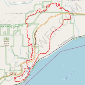
Interactive trail map
Trail profile
- Distance: 7.5 mi
- Elevation gain: 875 m
- Maximum elevation: 390 m
- Elevation loss: 875 m
- Minimum elevation: 25 m
About this trail
Name: Cape Horn Loop trail, distance, elevation, map, profile, GPS track
Start: Cape Horn Trail, Skamania County, Washington, 97010, United States (45.58939 -122.17916)
End: Cape Horn Trail, Skamania County, Washington, 97010, United States (45.58939 -122.17916)
Coordinates: 45.56712 -122.20401 45.59210 -122.17844
Other hiking, mountain biking, running and outdoor activity trails
Click on a trail to view its statistics, map and profile.
Cape Horn Loop Trail in Columbia River Gorge National Scenic Area
United States > Washington > Skamania County
The Cape Horn Loop Trail offers hikers a blend of forested paths, panoramic viewpoints, and intriguing geological formations, making it a fantastic hike in the Columbia River Gorge. Along the route, visitors can enjoy sweeping views of the Columbia River, including distant landmarks like Beacon Rock and…
Distance: 7.0 mi • Elevation gain: 634 m • Maximum elevation: 388 m
Cape Horn Viewpoint Loop via Cape Horn Trail, Cape Horn Falls, Windblown Fir Viewpoint and Pioneer Point
United States > Washington > Skamania County
The Cape Horn Viewpoint Loop in Gifford Pinchot National Forest offers an immersive hiking experience with a variety of stunning landscapes. As you hike, you'll enjoy panoramic views of the Columbia River Gorge, including nearby peaks like Hamilton Mountain. The trail also passes the scenic Cape Horn Falls and…
Distance: 6.5 mi • Elevation gain: 569 m • Maximum elevation: 388 m
Expedition to Sedum Ridge
United States > Oregon > Multnomah County > Portland
Distance: 133.4 mi • Elevation gain: 5,093 m • Maximum elevation: 1,169 m