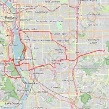
Portland Gravel/Unpaved Cycling
- Distance: 31.0 mi
- Elevation gain: 560 m
- Maximum elevation: 145 m
- Elevation loss: 560 m
- Minimum elevation: -1 m
- Moving time: 2 h 53 m
- Moving speed: 10.7 mph
- Maximum speed: 34.0 mph
- Total time: 4 h 17 m
- Global speed: 7.2 mph
Interactive trail map
Trail profile
- Distance: 31.0 mi
- Elevation gain: 560 m
- Maximum elevation: 145 m
- Elevation loss: 560 m
- Minimum elevation: -1 m
- Moving time: 2 h 53 m
- Moving speed: 10.7 mph
- Maximum speed: 34.0 mph
- Total time: 4 h 17 m
- Global speed: 7.2 mph
About this trail
Name: Portland Gravel/Unpaved Cycling trail, distance, elevation, map, profile, GPS track
Coordinates: 45.44929 -122.68617 45.50497 -122.51977
Other hiking, mountain biking, running and outdoor activity trails
Click on a trail to view its statistics, map and profile.
Portland Cyclocross - Happy Valley trails
United States > Oregon > Multnomah County > Portland
Distance: 13.1 mi • Elevation gain: 549 m • Maximum elevation: 321 m
Expedition to Sedum Ridge
United States > Oregon > Multnomah County > Portland
Distance: 133.4 mi • Elevation gain: 5,093 m • Maximum elevation: 1,169 m
The Watcher in the Water
United States > Oregon > Multnomah County > Portland
Distance: 51.5 mi • Elevation gain: 1,451 m • Maximum elevation: 300 m
Lake Oswego trails
United States > Oregon > Multnomah County > Portland
Happy Hour Lake Oswego
Distance: 43.2 mi • Elevation gain: 1,173 m • Maximum elevation: 222 m