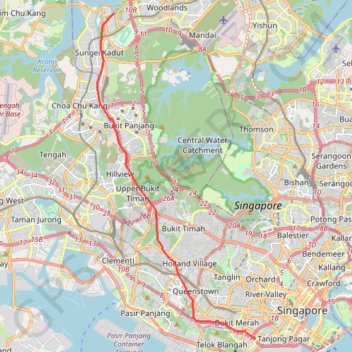
The Green Corridor - Singapore
- Distance: 13.8 mi
- Elevation gain: 167 m
- Maximum elevation: 44 m
- Elevation loss: 156 m
- Minimum elevation: 7 m
Interactive trail map
Trail profile
- Distance: 13.8 mi
- Elevation gain: 167 m
- Maximum elevation: 44 m
- Elevation loss: 156 m
- Minimum elevation: 7 m
About this trail
Name: The Green Corridor - Singapore trail, distance, elevation, map, profile, GPS track
Start: Woodlands Road, Sungei Kadut, Northwest, Singapore, 738782, Singapore (1.43391 103.76055)
End: Rail Corridor, Radin Mas, Bukit Merah, Central, Singapore, 159553, Singapore (1.27638 103.82891)
Coordinates: 1.27569 103.75245 1.43391 103.82901
Other hiking, mountain biking, running and outdoor activity trails
Click on a trail to view its statistics, map and profile.
Bukit Timah Hill - MacRitchie Reservoir
Distance: 9.2 mi • Elevation gain: 290 m • Maximum elevation: 167 m
Singapore Botanical Gardens
Distance: 6.6 mi • Elevation gain: 161 m • Maximum elevation: 40 m
Singapore Botanical Gardens.gpx
Distance: 6.6 mi • Elevation gain: 161 m • Maximum elevation: 40 m
MacRitchie Reservoir and TreeTop Walk Loop
Distance: 7.6 mi • Elevation gain: 207 m • Maximum elevation: 89 m
Tree Top Walk & Bukit Timah Hill in Central Catchment Nature Reserve
Distance: 8.8 mi • Elevation gain: 319 m • Maximum elevation: 166 m
Rail Corridor
Distance: 5.4 mi • Elevation gain: 111 m • Maximum elevation: 53 m
Singapore Botanical Gardens
Distance: 6.6 mi • Elevation gain: 161 m • Maximum elevation: 40 m
Directions from Duck Tour Ramp to Marina Boulevard, Singapore
Distance: 65.5 mi • Elevation gain: 812 m • Maximum elevation: 51 m
Mandai Boardwalk
Distance: 2.8 mi • Elevation gain: 28 m • Maximum elevation: 43 m
Yale NUS walking
Distance: 0.9 mi • Elevation gain: 31 m • Maximum elevation: 25 m