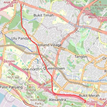
Rail Corridor
- Distance: 5.4 mi
- Elevation gain: 111 m
- Maximum elevation: 53 m
- Elevation loss: 143 m
- Minimum elevation: 10 m
- Moving time: 38 m 20 s
- Moving speed: 8.4 mph
- Maximum speed: 16.9 mph
- Total time: 42 m 9 s
- Global speed: 7.6 mph
Interactive trail map
Trail profile
- Distance: 5.4 mi
- Elevation gain: 111 m
- Maximum elevation: 53 m
- Elevation loss: 143 m
- Minimum elevation: 10 m
- Moving time: 38 m 20 s
- Moving speed: 8.4 mph
- Maximum speed: 16.9 mph
- Total time: 42 m 9 s
- Global speed: 7.6 mph
About this trail
Name: Rail Corridor trail, distance, elevation, map, profile, GPS track
Start: 1, Telok Blangah Crescent, Bukit Merah, Central, Singapore, 090011, Singapore (1.27946 103.81761)
Coordinates: 1.27946 103.78128 1.33580 103.81823
Other hiking, mountain biking, running and outdoor activity trails
Click on a trail to view its statistics, map and profile.
Singapore Botanical Gardens
Distance: 6.6 mi • Elevation gain: 161 m • Maximum elevation: 40 m
Singapore Botanical Gardens.gpx
Distance: 6.6 mi • Elevation gain: 161 m • Maximum elevation: 40 m
The Green Corridor - Singapore
Distance: 13.8 mi • Elevation gain: 167 m • Maximum elevation: 44 m
Singapore Botanical Gardens
Distance: 6.6 mi • Elevation gain: 161 m • Maximum elevation: 40 m
Directions from Duck Tour Ramp to Marina Boulevard, Singapore
Distance: 65.5 mi • Elevation gain: 812 m • Maximum elevation: 51 m