Make a donation
Gear up for your next adventure:
As an Amazon Associate, this site earns from qualifying purchases at no extra cost to you.
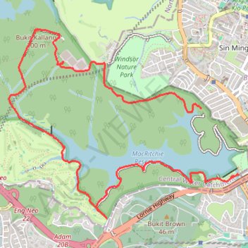
新加坡-麦里芝自然小径
- Distance: 7.4 mi
- Elevation gain: 192 m
- Maximum elevation: 89 m
- Elevation loss: 201 m
- Minimum elevation: 10 m
- Moving time: 3 h 16 m
- Moving speed: 2.3 mph
- Maximum speed: 8.8 mph
- Total time: 4 h 1 m
- Global speed: 1.8 mph
Interactive trail map
Make a donation
Gear up for your next adventure:
As an Amazon Associate, this site earns from qualifying purchases at no extra cost to you.
Trail profile
- Distance: 7.4 mi
- Elevation gain: 192 m
- Maximum elevation: 89 m
- Elevation loss: 201 m
- Minimum elevation: 10 m
- Moving time: 3 h 16 m
- Moving speed: 2.3 mph
- Maximum speed: 8.8 mph
- Total time: 4 h 1 m
- Global speed: 1.8 mph
Make a donation
Gear up for your next adventure:
As an Amazon Associate, this site earns from qualifying purchases at no extra cost to you.
About this trail
Name: 新加坡-麦里芝自然小径 trail, distance, elevation, map, profile, GPS track
Coordinates: 1.33686 103.80599 1.36137 103.83579
Make a donation
Gear up for your next adventure:
As an Amazon Associate, this site earns from qualifying purchases at no extra cost to you.
Other hiking, mountain biking, running and outdoor activity trails
Click on a trail to view its statistics, map and profile.
Bukit Timah Hill - MacRitchie Reservoir
Distance: 9.2 mi • Elevation gain: 290 m • Maximum elevation: 167 m
MacRitchie Reservoir and TreeTop Walk Loop
Distance: 7.6 mi • Elevation gain: 207 m • Maximum elevation: 89 m
The Green Corridor - Singapore
Distance: 13.8 mi • Elevation gain: 167 m • Maximum elevation: 44 m
Tree Top Walk & Bukit Timah Hill in Central Catchment Nature Reserve
Distance: 8.8 mi • Elevation gain: 319 m • Maximum elevation: 166 m
Make a donation
Gear up for your next adventure:
As an Amazon Associate, this site earns from qualifying purchases at no extra cost to you.
Directions from Duck Tour Ramp to Marina Boulevard, Singapore
Distance: 65.5 mi • Elevation gain: 812 m • Maximum elevation: 51 m