Import a GPX file

Cental Catchment Nature Reserve

Walk from the zoo. #Hiking #Park #Nature #Lake #Forest

  • Distance: 5.2 mi
  • Elevation gain: 71 m
  • Maximum elevation: 49 m
  • Elevation loss: 97 m
  • Minimum elevation: 11 m

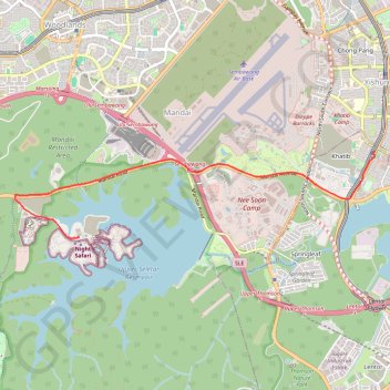
Interactive trail map

Trail profile

  • Distance: 5.2 mi
  • Elevation gain: 71 m
  • Maximum elevation: 49 m
  • Elevation loss: 97 m
  • Minimum elevation: 11 m

About this trail

Name: Cental Catchment Nature Reserve trail, distance, elevation, map, profile, GPS track

Start: Mandai Lake Road, Mandai Nature Precinct, Central Water Catchment, Northwest, Singapore, 729826, Singapore (1.40442 103.78839)

End: Yishun Avenue 2, Khatib, Yishun, Northwest, Singapore, 769092, Singapore (1.41750 103.83340)

Coordinates: 1.40427 103.77857 1.41750 103.83351

Other hiking, mountain biking, running and outdoor activity trails

Click on a trail to view its statistics, map and profile.

The Green Corridor - Singapore

Singapore > Singapore

#Hiking

Distance: 13.8 mi • Elevation gain: 167 m • Maximum elevation: 44 m

Directions from Duck Tour Ramp to Marina Boulevard, Singapore

Singapore > Singapore

Distance: 65.5 mi • Elevation gain: 812 m • Maximum elevation: 51 m

Mandai Boardwalk

Singapore > Singapore

Distance: 2.8 mi • Elevation gain: 28 m • Maximum elevation: 43 m

Gear up for your next adventure:

🔥Emergency Fire Starters - Reliable ignition tools for survival situations in damp conditions
🥄Titanium Camping Sporks - The ultimate lightweight utensil for trail meals
📱Phone Mounts for Hiking - Secure mounts to carry your phone on trails
🧣Fleece Neck Warmers - Extra insulation for winter topographic surveys
📸Action Camera Chest Mounts - Record your ascent following topographic paths hands-free

As an Amazon Associate, this site earns from qualifying purchases at no extra cost to you.