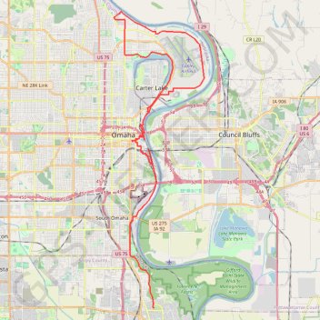
Bellevue Omaha Cycling
- Distance: 28.1 mi
- Elevation gain: 266 m
- Maximum elevation: 360 m
- Elevation loss: 297 m
- Minimum elevation: 294 m
- Moving time: 2 h 34 m
- Moving speed: 10.9 mph
- Maximum speed: 26.5 mph
- Total time: 2 h 41 m
- Global speed: 10.4 mph
Interactive trail map
Trail profile
- Distance: 28.1 mi
- Elevation gain: 266 m
- Maximum elevation: 360 m
- Elevation loss: 297 m
- Minimum elevation: 294 m
- Moving time: 2 h 34 m
- Moving speed: 10.9 mph
- Maximum speed: 26.5 mph
- Total time: 2 h 41 m
- Global speed: 10.4 mph
About this trail
Name: Bellevue Omaha Cycling trail, distance, elevation, map, profile, GPS track
Start: 1608, Elm Street, Avery, Bellevue, Sarpy County, Nebraska, 68005, United States (41.16159 -95.91565)
Coordinates: 41.16139 -95.94541 41.32761 -95.87662
Other hiking, mountain biking, running and outdoor activity trails
Click on a trail to view its statistics, map and profile.
Lauritzen Gardens walk
United States > Nebraska > Douglas County > Omaha
Distance: 2.3 mi • Elevation gain: 60 m • Maximum elevation: 339 m
Loop hike in Fontenelle Forest via Hackberry Trail, Hawthorn Trail, Chickadee Trail, Riverview Boardwalk and Ridge Trail
United States > Nebraska > Sarpy County > Bellevue
This loop hike through Fontenelle Forest showcases a variety of scenic environments. Hikers can enjoy lush woodlands, open views of the Missouri River, and opportunities for wildlife observation, including various bird species. The well-maintained paths offer a mix of gentle slopes and boardwalks, making it…
Distance: 2.5 mi • Elevation gain: 121 m • Maximum elevation: 356 m
Bob Kerrey Pedestrian Bridge in Omaha
United States > Nebraska > Douglas County > Omaha
The Bob Kerrey Pedestrian Bridge offers a pleasant and scenic route for walkers and cyclists, spanning across the Missouri River between Omaha, Nebraska, and Council Bluffs, Iowa. As you hike the bridge, you can enjoy panoramic views of both city skylines, the river, and nearby parks, including access to the…
Distance: 1.3 mi • Elevation gain: 26 m • Maximum elevation: 305 m