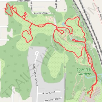
Lauritzen Gardens walk
- Distance: 2.3 mi
- Elevation gain: 60 m
- Maximum elevation: 339 m
- Elevation loss: 57 m
- Minimum elevation: 311 m
- Moving time: 1 h 14 m
- Moving speed: 1.9 mph
- Maximum speed: 3.6 mph
- Total time: 1 h 26 m
- Global speed: 1.6 mph
Interactive trail map
Trail profile
- Distance: 2.3 mi
- Elevation gain: 60 m
- Maximum elevation: 339 m
- Elevation loss: 57 m
- Minimum elevation: 311 m
- Moving time: 1 h 14 m
- Moving speed: 1.9 mph
- Maximum speed: 3.6 mph
- Total time: 1 h 26 m
- Global speed: 1.6 mph
About this trail
Name: Lauritzen Gardens walk trail, distance, elevation, map, profile, GPS track
Coordinates: 41.23456 -95.92329 41.24051 -95.91552
Other hiking, mountain biking, running and outdoor activity trails
Click on a trail to view its statistics, map and profile.
Bellevue Omaha Cycling
United States > Nebraska > Sarpy County > Bellevue
Distance: 28.1 mi • Elevation gain: 266 m • Maximum elevation: 360 m